Canterbury & Kent
AI and Drone Technology in UK Building Surveys: How 3D Scanning Is Transforming Reports in 2026
A drone can now capture a complete residential roof survey in under an hour, generating a millimetre-accurate 3D point cloud that would have taken a team of scaffolders two days to produce manually. That shift is not a future prospect, it is the operational reality of AI and drone technology in UK building surveys: how 3D scanning is transforming reports in 2026. From LiDAR-equipped UAVs to mandatory RICS artificial intelligence standards, the profession is undergoing its most significant technical evolution in decades.
Key Takeaways
- RICS made its first global AI standard mandatory for all members from 9 March 2026, requiring written AI registers, risk registers, and client transparency whenever AI materially affects survey outputs.
- Drone-based reality capture has moved from specialist niche to mainstream practice, with 52% of UK and Irish construction firms now using drone-based digital information.
- Integrated LiDAR, photogrammetry, and AI workflows can capture a typical residential property in 30 to 60 minutes, with AI then classifying surfaces, detecting defects, and flagging anomalies for surveyor review.
- 3D scanning accuracy benchmarks range from approximately 1.9 mm for static LiDAR to 20 to 50 mm for UAV photogrammetry, adequate for most building condition surveys and accepted by Building Control.
- Surveyors remain professionally responsible for all outputs; AI is a governed, assistive tool, not a replacement for expert judgement.
The RICS AI Standard: A Mandatory Framework for 2026
The single most consequential regulatory development shaping AI and drone technology in UK building surveys is the RICS standard on the responsible use of artificial intelligence. From 9 March 2026, this became mandatory for all RICS members and regulated firms globally [2][9]. The standard sets binding requirements across four domains: governance, data use, risk management, and client transparency, applying whenever AI materially affects survey outputs [3].
The practical obligations are substantial. Firms must maintain a written AI register documenting every AI tool in use, alongside a risk register identifying potential failure modes. The standard explicitly warns about AI hallucinations, instances where a system generates plausible but incorrect outputs, and algorithmic bias, both of which carry serious professional risk in a building survey context [5][7]. Surveyors are further required to explain AI use and its limitations to clients in plain terms, meaning that a report produced with AI-assisted defect recognition must disclose that fact and describe what human oversight was applied [3][7].
Legal analysis published in 2026 underlines that responsible AI policies are now an essential component of practice management for any firm using AI-driven 3D scanning and analytics [7]. The standard is not designed to restrict innovation; rather, as RICS frames it, the goal is to “elevate surveyors’ professional judgement” by formalising oversight, explainability, and transparency [5].
For clients commissioning a Level 3 Building Survey or a specialist defect survey, this means they can now expect explicit disclosure of any AI tools used in their report, along with a clear statement of how the surveyor verified those outputs.
Key regulatory point: The RICS AI standard does not permit AI to replace professional judgement. It requires surveyors to document, explain, and take responsibility for every AI-assisted finding.
What the RICS Home Survey Standard Now Covers
The RICS Home Survey Standards are being updated to explicitly reference AI, drone inspections, and technology-rich reporting [8][10]. Review documentation highlights cross-referencing of technological advancements including AI, drone roof inspections, thermal imaging, and structured digital reporting platforms [8][6]. Practitioners in 2026 note that the 2nd Edition Home Survey Standard now covers AI-assisted defect recognition and drone-based elevation surveys as recognised methodologies within the standard framework [6][10].
The Home Survey Standard 2nd Edition key updates represent a formal acknowledgement that these technologies are no longer experimental. They are part of how compliant, high-quality surveys are expected to be conducted and reported.
How 3D Scanning and Drone Workflows Are Changing Defect Detection
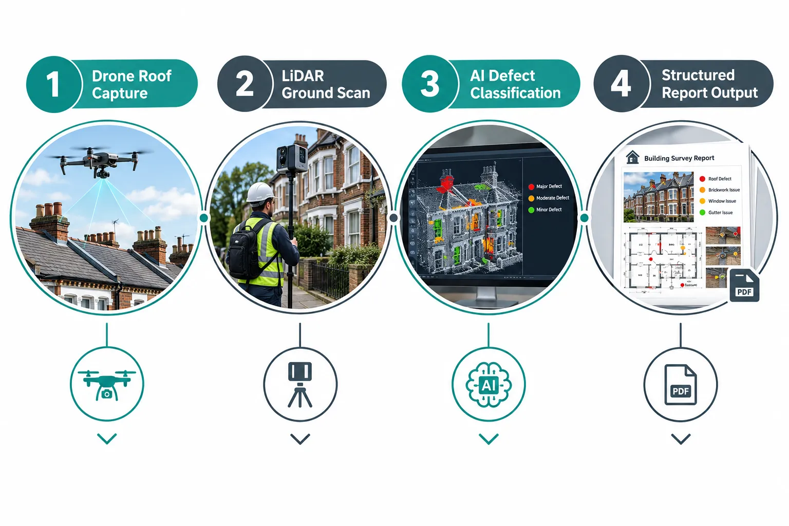
The core technical shift in AI and drone technology in UK building surveys is the move from sequential, manual inspection to integrated reality-capture workflows. A typical 2026 residential survey workflow combines mobile LiDAR scanning, 360-degree imagery, and drone roof and external capture in a single site visit [1]. The entire data-capture phase for a standard residential property can be completed in 30 to 60 minutes, after which AI processes the raw data to classify surfaces, detect structural elements, generate floor plans, and flag anomalies for the surveyor to review.
Accuracy Benchmarks Across Survey Technologies
Different capture methods suit different project types and accuracy requirements. The table below summarises current performance benchmarks for UK building survey applications:
| Method | Accuracy | Speed Advantage | Typical Application |
|---|---|---|---|
| Static LiDAR | ~1.9 mm control-point precision | Baseline | Measured building surveys, heritage |
| Mobile LiDAR (SLAM) | 15 to 20 mm | Up to 10x faster than static | Indoor existing buildings |
| UAV Photogrammetry | 20 to 50 mm | 5 to 8x faster than traditional | Small residential plots |
| Drone LiDAR (RTK GPS) | ~20 mm | Rapid deployment | Medium commercial sites, facades |
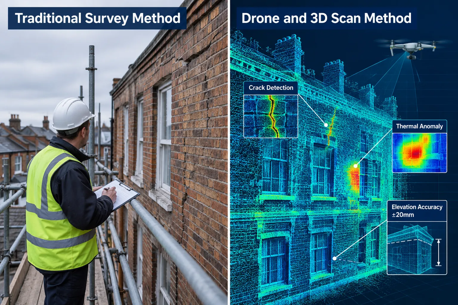
For the vast majority of building condition surveys, 20 mm accuracy is more than sufficient. UK Building Control now widely accepts drone imagery as official evidence for sign-off when captured by certified professionals using calibrated equipment.
Drone Roof Inspections: Replacing Scaffolding With 24-Hour Deployment
Drone-enabled roof and facade surveys represent the most visible practical change for clients. Where a traditional roof inspection required scaffolding, access equipment, and multiple days on site, a commercial drone operator can deploy within 24 hours, capture 4K imagery and photogrammetric data, and deliver a measurement-accurate 3D model suitable for structural assessment, cladding surveys, and remedial planning.
Specialist UK providers now offer integrated services combining high-resolution RGB imagery, IEC 62446-compliant thermal imaging for solar PV arrays, and 3D point clouds for commercial properties [1]. This is directly relevant to commercial building surveys and roof surveys, where access constraints have historically limited inspection depth.
Industry adoption data confirms the scale of this shift. A survey of UK and Irish construction firms found that 52% of respondents now use drone-based digital or reality-capture information, up from 33% in 2017, with further respondents planning adoption [1]. RICS runs dedicated CPD webinars on drone and laser scanning applications in residential surveying, signalling institutional endorsement of these methods [1].
AI-Driven Defect Recognition: What It Means in Practice
Once raw point-cloud and imagery data is captured, AI classification tools analyse the dataset to identify surface anomalies, crack patterns, moisture indicators from thermal imaging, and structural deviations. The AI flags potential defects and generates a structured anomaly report, which the surveyor then reviews, verifies, and incorporates into the final report.
This workflow is particularly powerful for major defects reports where comprehensive coverage of a complex building is required. AI can process thousands of data points from a single scan session, reducing the risk of missed defects in hard-to-access areas such as high parapets, concealed gutters, and upper-storey brickwork.
Platforms such as DroneDeploy have introduced Progress AI features that read reality-capture data, compare it against reference conditions, and generate deviation reports automatically. UK contractors including major construction firms have standardised these platforms across dozens of projects, reinforcing AI-driven reality capture as part of mainstream surveying workflows.
Regulatory Compliance, Costs, and the Path to Mainstream Adoption
The regulatory environment for commercial drone operations in the UK tightened significantly in 2026. Commercial operators must hold a CAA General Visual Line of Sight Certificate (GVC), comply with new class markings, and broadcast Remote ID signals under rules introduced from January 2026 [1]. A further update, CAA Decision No. 60, effective 1 October 2026, aligns UK autonomous drone workflows with the international JARUS SORA 2.5 methodology, affecting how operators conduct risk assessments for flights near buildings and populated areas [1].

These requirements mean that not every firm can simply acquire a drone and begin offering survey services. Compliant drone survey work requires certified operators, calibrated equipment, documented risk assessments, and privacy-compliant data handling. For clients, this is a quality filter: a drone survey delivered by a GVC-certified operator with documented methodology carries professional credibility that an ad hoc flight does not.
Cost Benchmarks: 3D Scanning Now Accessible for Routine Surveys
One of the most significant changes in 2026 is the financial accessibility of 3D scanning for standard building surveys. UK providers now list drone roof inspections from approximately £349, topographic drone surveys for plots up to 0.5 hectares from £599, LiDAR and measured building surveys from £1,199, and Scan-to-BIM projects from £1,499 per floor at LOD 200. These price points mean that fully 3D point-cloud-based reports and BIM outputs are now practical for routine residential and commercial surveys, not just major development projects.
What this means for survey clients:
- Drone roof inspection data can now be included in a standard building survey at a modest additional cost
- LiDAR-based measured surveys are viable for pre-purchase due diligence on complex or non-standard properties
- BIM-ready outputs support planning applications, refurbishment projects, and dilapidations assessments
For those considering a building survey for a conventional or non-standard home, the availability of drone and LiDAR data at these price points changes the calculus for what level of investigation is proportionate.
Scan-to-BIM and Dilapidations: Commercial Applications
In the commercial sector, the integration of drone and LiDAR data into BIM workflows is reshaping how dilapidations assessments and stock condition surveys are conducted. Dense point clouds captured by SLAM scanners and UAVs are processed into measured building surveys, elevation drawings, and BIM-ready models that support lease-end negotiations and planned maintenance programmes.
For dilapidation surveys and stock condition surveys, the ability to produce a dimensionally accurate as-built record from a single site visit, rather than multiple manual measurement sessions, reduces both cost and programme time while improving the evidential quality of the report.
The RICS commercial building survey framework increasingly expects surveyors to consider whether technology-enhanced capture methods are appropriate for a given instruction, particularly where access is restricted or the building envelope is complex.
Balancing Technology With Professional Responsibility
A recurring theme in RICS guidance and legal commentary throughout 2026 is the importance of maintaining professional judgement as the governing principle, with AI and drone data as inputs rather than conclusions. Expert commentary from RICS Modus and the Construction Journal emphasises unease about relying on opaque AI outputs in expert-witness contexts [4][5]. The new AI standard directly addresses this by requiring explainability and documented oversight at every stage [3][7].
For surveyors, this means the workflow does not end with an AI anomaly report. Every flagged item requires professional assessment, contextualisation within the building’s history and construction type, and a reasoned conclusion expressed in the surveyor’s own professional judgement. The technology accelerates data collection and improves coverage; the surveyor’s expertise determines what that data means.
This principle applies equally to expert witness inspections and evidence gathering, where the provenance, methodology, and human verification of AI-assisted findings will face scrutiny in dispute proceedings.
Conclusion
AI and drone technology in UK building surveys represents a genuine step change in how defects are detected, how roofs and facades are inspected, and how reports are structured and delivered. The combination of mandatory RICS AI governance standards, accessible 3D scanning costs, and maturing drone compliance frameworks means that technology-enhanced surveys are no longer a premium add-on, they are becoming the expected standard for thorough, defensible building assessments in 2026.
Actionable next steps for property buyers, owners, and professionals:
- Ask your surveyor directly whether drone and AI-assisted methods will be used in your survey, and request disclosure of the AI register and methodology as required by the RICS standard.
- Match the survey level to the technology available. For complex, non-standard, or high-value properties, a Level 3 Building Survey with RICS-level 3 protocols combined with drone roof capture and LiDAR provides the most comprehensive evidence base.
- Verify operator credentials. Confirm that any drone survey is conducted by a CAA GVC-certified operator with documented risk assessment and Remote ID compliance.
- Use the data downstream. Point cloud outputs and BIM models generated during a survey have lasting value for refurbishment planning, planning applications, and lease negotiations, request digital deliverables alongside the written report.
- Stay current with RICS guidance. The Home Survey Standard is actively evolving to incorporate these technologies; working with a surveyor who engages with RICS CPD on digital surveying ensures your report reflects current best practice [1][9].
Canterbury Surveyors combines RICS-aligned professional standards with awareness of these emerging technologies, ensuring that every building survey reflects both the depth of traditional expertise and the precision that modern reality-capture methods can deliver.
References
[1] Drones Applications And Compliance For Surveyors – rics.org
[2] Responsible Use Of Ai – rics.org
[3] Responsible Use Of Artificial Intelligence In Surveying Practice September 2025 – rics.org
[4] What Surveyors Think Ai – ww3.rics.org
[5] Ai Responsible Use Standard – ww3.rics.org
[6] Rics 2nd Edition Home Survey Standard 2025 Key Updates And Implementation Roadmap For Building Surveyors In 2026 – princesurveyors.co.uk
[7] Rics Sets The Standard Responsible Ai Use Becomes Mandatory In Surveying – beale-law.com
[8] Home Survey Standards – rics.org
[9] Rics First Ever Standard On Responsible Ai Use Now In Effect – rics.org
[10] Rics Home Survey Standards 2026 Technological Clarifications And Consumer Insights For Building Surveyors – princesurveyors.co.uk
Related services from Canterbury Surveyors
- Building expert witness surveyors
- Dilapidations surveyors
- Building Surveys (Level 3)
- Structural engineers in Canterbury & Kent
Get a fixed-fee quote or call 0204 579 8270.