
Canterbury & Kent
Why “Location” Is More Than a Postcode: Surveyor Insights into UK Property Risk, Access and Neighbour Disputes
Nearly one in five boundary disputes in England and Wales escalates to formal legal proceedings before any professional surveyor is consulted, a costly pattern that stems directly from buyers treating “location” as a postcode rather than a complex physical and legal reality. Why “Location” Is More Than a Postcode: Surveyor Insights into UK Property Risk, Access and Neighbour Disputes is a subject that chartered surveyors encounter on almost every instruction, because the attributes that truly determine a property’s risk profile, usability and long-term value operate at the level of the individual plot, not the neighbourhood.
This article unpacks what surveyors actually examine when they assess a property’s location, from flood risk and subsidence geology to access easements, party wall obligations and the precise position of a garden fence.
Key Takeaways
- A postcode reveals neighbourhood trends but conceals plot-specific risks such as flood exposure, subsidence-prone soils, access restrictions and disputed boundaries.
- RICS professional standards confirm that legal title plans are only a starting point; on-the-ground features, historic conveyances and topographic surveys are equally important evidence [2].
- Boundary and neighbour disputes are among the most common property conflicts in England and Wales, and most are preventable with early surveyor involvement [7][8].
- The Party Wall etc. Act 1996 creates statutory access rights and obligations that attach to specific party structures, not postcodes, making site-level analysis essential before any notifiable works begin [4].
- Instructing a chartered surveyor before exchange of contracts, not after, is the single most effective way to identify location-specific risks that no automated valuation or postcode search will reveal.
What Surveyors Mean When They Talk About “Location”
Estate agents use “location” to mean school catchment areas, commuter links and neighbourhood prestige. Surveyors use the same word to mean something far more granular: the precise physical, legal and environmental conditions that attach to a specific parcel of land. Understanding this distinction is at the heart of why “Location” Is More Than a Postcode: Surveyor Insights into UK Property Risk, Access and Neighbour Disputes matters to every buyer, seller and investor in the UK market.
The Four Hidden Risk Layers
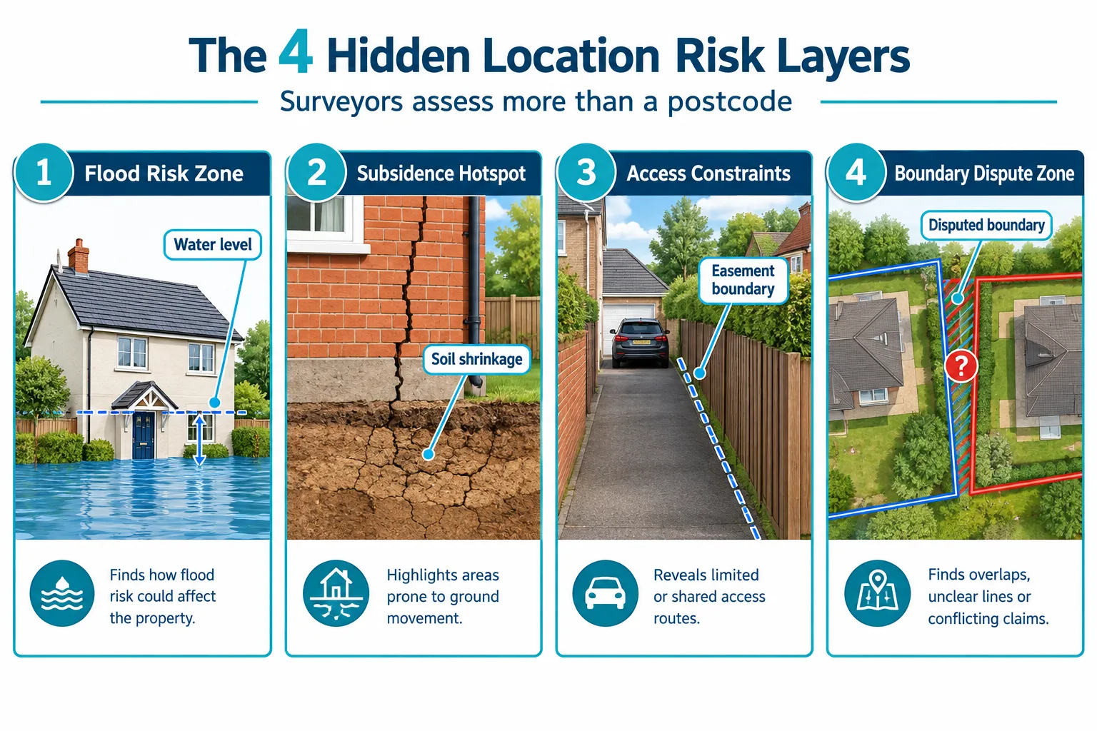
When a chartered surveyor assesses a property, they are simultaneously reading four overlapping layers of location risk that no postcode search will surface:
| Risk Layer | What It Covers | Why Postcode Data Misses It |
|---|---|---|
| Environmental risk | Flood zones, subsidence geology, contaminated land | Risk varies street by street, even plot by plot |
| Legal title | Boundary lines, covenants, easements | Title plans are indicative, not definitive [2] |
| Physical access | Rights of way, shared driveways, ransom strips | Often unregistered or poorly described in deeds |
| Neighbour interface | Party walls, shared structures, right to light | Depends on exact building geometry and adjacency |
Flood risk is a clear example of postcode-level data failing buyers. Two properties in the same postcode can sit in entirely different Environment Agency flood zones if one is on slightly lower ground or closer to a culverted watercourse. A surveyor carrying out a homebuyer survey will check flood zone mapping at the plot level, review drainage arrangements and note any evidence of previous water ingress, none of which appears in a postcode-level flood score.
Subsidence follows a similarly localised pattern. Clay soils in parts of London, Essex and the South East shrink dramatically in dry summers, causing differential settlement in properties built on shallow foundations. The risk is not uniform across a postcode; it can vary between adjacent houses depending on tree proximity, drainage and foundation depth. Surveyors cross-reference British Geological Survey data with on-site observations of cracking patterns, door and window distortion, and drainage condition.
“The legal title plan is only the starting point. It must be interpreted alongside on-the-ground features, historic conveyances and survey data.”, RICS Boundaries Guidance Note, 4th Edition [2]
Contaminated land is another risk that postcode searches routinely miss. Former industrial uses, gas works, tanneries, dry-cleaning premises, can leave residual contamination on individual plots within otherwise clean residential streets. A surveyor familiar with local history will flag the need for a Phase 1 environmental search where the site history raises concern.
For buyers considering investment properties, understanding these layered risks is as important as running yield calculations. The yield vs comparable valuation methods surveyor checklists for residential investments specifically address how location-specific risk factors should be weighed against headline return figures.
Boundaries, Title Plans and the Gap Between Paper and Reality
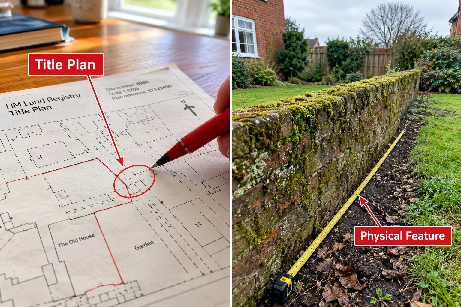
The single most persistent source of neighbour conflict in England and Wales is the boundary, specifically, the gap between where a title plan suggests a boundary runs and where it actually sits on the ground. RICS’ professional standard on boundary identification confirms that legal title plans are only a starting point and must be interpreted alongside on-the-ground features, historic conveyances and survey data [2]. This is why surveyors treat boundary analysis as a core component of location risk assessment, not an optional add-on.
Why Title Plans Are Not Enough
HM Land Registry title plans are drawn at a scale of 1:1250 for urban properties and 1:2500 for rural ones. At those scales, a line width of one millimetre on the plan can represent anywhere from 125 mm to 250 mm on the ground. That tolerance is wide enough to place a fence, wall or outbuilding entirely on the wrong side of the legal boundary.
RICS consumer guidance on boundary disputes advises buyers to:
- Obtain the HM Land Registry title plan and any available historic conveyances.
- Walk the boundary and compare physical features, fences, walls, hedges, ditches, with the plan.
- Discuss maintenance responsibility with neighbours before exchange of contracts.
- Consult a chartered land surveyor when boundaries are unclear [7][8].
The RICS consumer guide on topographic surveys and boundary disputes, updated in August 2026, highlights that a detailed site survey is particularly important when planned construction will remove existing boundary features, since those features may be the only reliable evidence of the true boundary line [12]. Once a hedge is grubbed out or a wall demolished, that evidence is gone.
Common Triggers for Boundary Disputes
Solicitors and surveyors in 2026 continue to identify the following as the most frequent triggers for boundary conflicts [9][7]:
- Unclear hedges and ditches, ownership of natural features is governed by common law presumptions that many owners are unaware of.
- Shared outbuildings and garages, often built straddling boundaries without formal documentation.
- Encroaching extensions, rear and side extensions that inch over the boundary during construction.
- Replacement fencing, a new fence erected slightly inside or outside the original line can establish a de facto boundary over time.
- Sold-off plots, when part of a larger property is sold, the retained and transferred boundaries are often described imprecisely.
The RICS Neighbour Disputes Service (NDS) positions chartered surveyors as independent experts within a three-stage resolution process: expert evaluation, facilitated negotiation, and expert witness [1]. Crucially, the NDS framework emphasises that site inspections and local physical conditions, not just title documents, are the critical evidence base in boundary and neighbour disputes [1]. This reinforces why location analysis must be physical, not just documentary.
Understanding how land surveys can clarify boundary positions before a dispute crystallises is explored in detail in the guide to how land surveys boost property value, boundary clarity and development potential.
Access Rights, Party Walls and the Neighbour Interface
Access is one of the most underestimated components of property location. A property may have a prestigious postcode but be effectively landlocked for development purposes by an unregistered ransom strip, a poorly documented right of way, or a shared driveway arrangement that gives a neighbour effective veto over any building works. In 2026, surveyors treat access analysis as a core part of location risk assessment precisely because access constraints can make the difference between a property that can be extended, converted or redeveloped and one that cannot [14].
Easements and Rights of Way
Rights of way, drainage easements and similar burdens are central to property value and usability, yet they are often poorly understood by lay owners [14]. Key distinctions that surveyors draw include:
- Pedestrian vs vehicular rights of way, a footpath right does not confer the right to drive over the same route, which matters enormously for properties accessed via shared tracks.
- Registered vs unregistered easements, many easements created before compulsory registration are not noted on the title register and must be identified through historic deeds and physical inspection.
- Express vs implied easements, easements of necessity (for example, the only access to a landlocked plot) may be implied by law even without express grant.
The new Property Information Form TA6 (sixth edition), mandatory from 30 March 2026, expands seller disclosure obligations and is being flagged by property lawyers as critical for managing misrepresentation risk linked to location-specific issues such as access, rights of way and neighbour problems [13][14]. Inaccurate or incomplete answers on the TA6 form can expose sellers to claims where buyers discover post-completion that access conditions differ from what was implied.
Party Wall Rights and Obligations
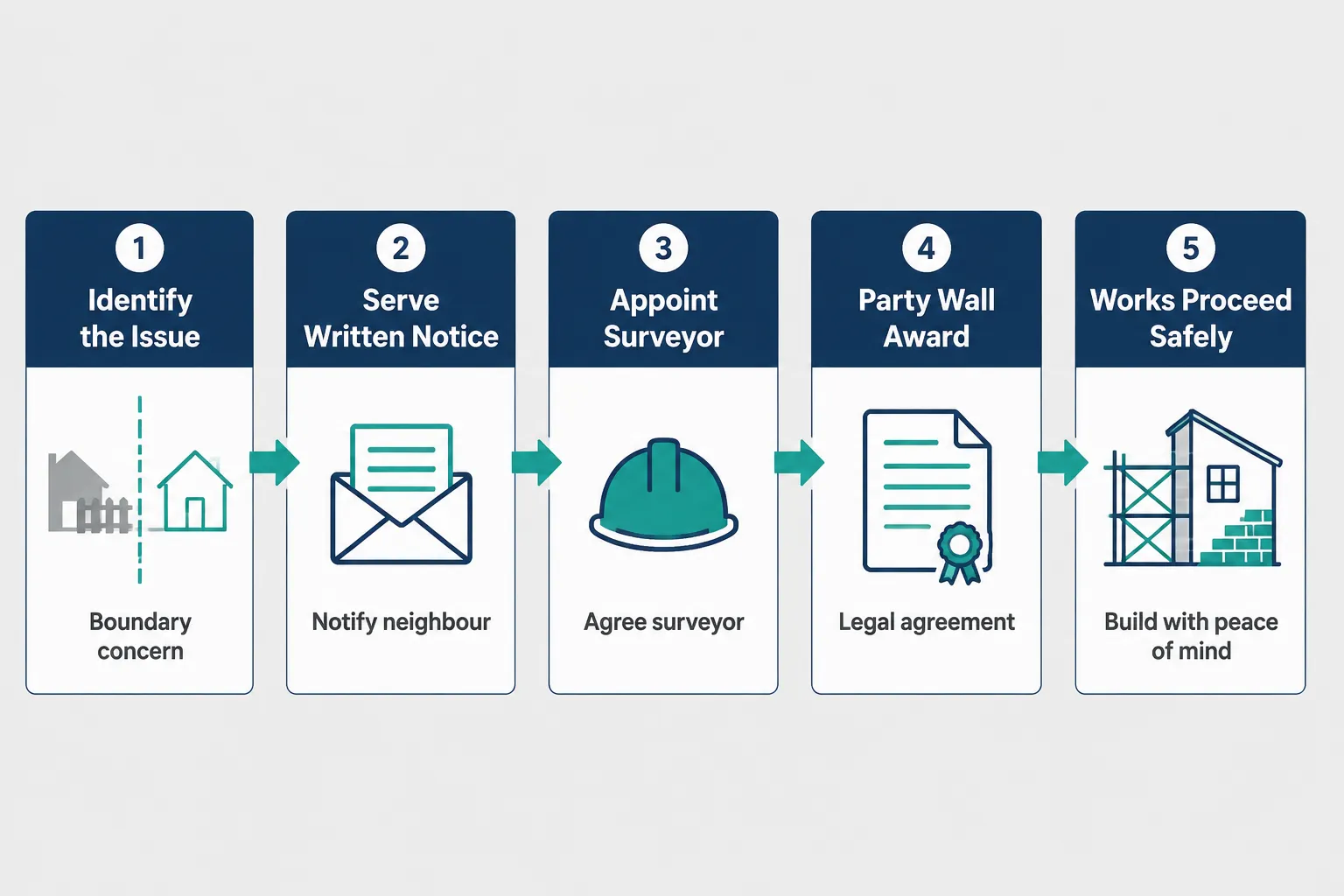
The Party Wall etc. Act 1996 creates a statutory framework that is entirely location-specific: it applies to the precise physical interface between two neighbouring properties, not to any broader area. Under the Act, a building owner carrying out notifiable works has a statutory right of access to adjoining land, subject to at least 14 days’ written notice [4][15]. Where neighbours do not consent to proposed works, one agreed surveyor or two separate surveyors must produce a Party Wall Award detailing the scope of work, timing, methods and the pre-works condition of the adjoining property [4].
This formal recording of local conditions and access arrangements at the party wall is used to allocate costs and reduce future damage claims [4][15]. The process is a practical demonstration of why property risk attaches to the exact physical interface between neighbouring plots, not the postcode area.
For a detailed look at how party wall surveyors are selected and how disputes are managed, the guide to Party Wall Act listed experts, profiles, selection criteria and success rates for 2026 disputes provides current benchmarks. Where works have already caused harm, the resource on damage to property in party wall sets out the remedies available.
Right to Light
Right to light is a further location-specific risk that buyers of properties near development sites frequently overlook. RICS guidance on this issue underlines that surveyors and specialist consultants assess room dimensions, window positions and the mass of proposed new buildings to quantify light loss [3]. The guidance advises raising concerns before construction starts, because once a building is erected, the remedies, compensation or court-ordered alterations, are far more costly than early negotiation [3].
The key variables, window orientation, room depth, the height and proximity of the neighbouring structure, are all micro-location attributes that vary from plot to plot within the same postcode. A buyer who relies on postcode-level due diligence will not identify this risk until it is too late.
The Role of In-Person Inspection
Post-pandemic RICS guidance on inspections and visits linked to neighbour disputes reinforces the importance of in-person inspection of the actual location, combined with documentary review, as the basis for reliable expert reports used by courts and mediation services [5]. No desktop search, automated valuation model or postcode database can substitute for a surveyor standing at the boundary, measuring the party wall, and examining the physical evidence of access use.
This is why choosing the right property survey is a decision with direct consequences for how thoroughly location-specific risks are identified. A Level 3 Building Survey will probe access arrangements, boundary features and party wall conditions in a way that a basic mortgage valuation will not. For buyers in areas with complex neighbouring structures or development potential, the additional cost of a more detailed survey is almost always justified by the risks it surfaces.
Where disputes have already reached the stage of formal proceedings, the construction disputes expert witness service illustrates how surveyors build the evidential case that courts and arbitrators rely upon, evidence that is, by definition, rooted in the specific physical location of the property in question.
Practical Steps for Buyers, Sellers and Investors
The insight that location means far more than a postcode translates into a set of concrete actions at each stage of a property transaction.
Before making an offer:
- Commission a preliminary boundary check using the title plan and a site visit.
- Run a plot-level flood risk and subsidence search, not just a postcode-level environmental report.
- Identify any shared access arrangements and verify whether they are formally documented.
- Check the TA6 Property Information Form answers carefully for any disclosed neighbour disputes, access issues or party wall notices.
Before exchange of contracts:
- Instruct a chartered surveyor for a Level 2 or Level 3 survey appropriate to the property’s age, type and complexity. Guidance on different types of survey comparison can help buyers select the right level of inspection.
- Ask the surveyor to comment specifically on boundary features, access arrangements and any evidence of neighbour disputes.
- If boundaries are unclear, commission a topographic survey to establish the physical position of all boundary features [12].
Before undertaking works:
- Identify all party structures and serve the correct notices under the Party Wall etc. Act 1996 before works begin.
- Obtain a pre-works schedule of condition for all adjoining properties.
- Take professional advice on any right-to-light implications before submitting a planning application for extensions or new buildings [3].
If a dispute arises:
- Engage a chartered surveyor as early as possible through the RICS Neighbour Disputes Service rather than proceeding directly to litigation [1].
- Gather all physical evidence, photographs, measurements, historic photographs, conveyance plans, before any features are disturbed.
- Consider the RICS three-stage resolution pathway (expert evaluation, facilitated negotiation, expert witness) as a cost-effective alternative to court proceedings [1][10].
Conclusion
The property market’s habitual shorthand, “it’s all about location, location, location”, is correct in principle but dangerously incomplete in practice. Why “Location” Is More Than a Postcode: Surveyor Insights into UK Property Risk, Access and Neighbour Disputes is not an abstract professional concern; it is a practical reality that costs buyers, sellers and investors significant sums every year when plot-specific risks go unidentified until after completion.
Chartered surveyors bring a discipline to location analysis that no postcode database can replicate: physical inspection, documentary cross-referencing, knowledge of local geology and planning history, and an understanding of the legal frameworks, from the Party Wall etc. Act to RICS boundary standards, that govern the precise interface between neighbouring properties.
Actionable next steps for anyone involved in a UK property transaction in 2026:
- Treat the postcode as a starting point, not a conclusion, for location risk assessment.
- Commission a survey at the appropriate level for the property’s complexity and value before exchange.
- Verify boundary features on the ground against the title plan, and instruct a topographic survey where any doubt exists.
- Check access arrangements and easements in the title deeds and the TA6 form, and seek clarification before exchange.
- Serve party wall notices in good time before any notifiable works, and appoint a chartered surveyor to manage the Award process.
- If a neighbour dispute arises, engage the RICS Neighbour Disputes Service early to avoid the disproportionate cost of litigation.
The difference between a property that performs as expected and one that becomes a source of ongoing cost and conflict almost always comes down to the quality of location analysis carried out before the ink dries on the contract.
References
[1] Neighbour Disputes Service – rics.org
[2] Boundaries Procedures For Boundary Identification Demarcation And Dispute Resolution Rics Guidance Note 4th Edition – rics.org
[3] Let There Be Light New Guidance For Homeowners Left In The Shadows – rics.org
[4] Rics Consumer Guide Party Walls 1 – chpk.co.uk
[5] Beyond Covid 19 Inspections And Visits Linked To Neighbour Disputes – rics.org
[7] Boundary Disputes Consumer Guide 2021 – rics.org
[8] Rics Consumer Guide Boundary Disputes – ricsfirms.com
[9] Insights – hansells.co.uk
[10] Download Feed – scribd.com
Related services from Canterbury Surveyors
- Party wall surveyors in Canterbury & Kent
- Boundary surveys
- Building expert witness surveyors
- RICS property valuations
Get a fixed-fee quote or call 0204 579 8270.