
Canterbury & Kent
Slope and Foundations: How UK Surveyors Assess Gradient Risk Before You Buy or Extend a Property
Nearly one in ten insurance claims on UK residential properties involves some form of ground movement, yet the majority of buyers never commission a specialist assessment of site gradient before exchanging contracts. Understanding Slope and Foundations: How UK Surveyors Assess Gradient Risk Before You Buy or Extend a Property is no longer a niche concern reserved for hillside mansions in the Peak District. In 2026, with the British Geological Survey’s GeoSure dataset now providing complete national coverage at 1:50,000 scale [3][4], every buyer, developer and homeowner planning an extension has access to, and a professional obligation to consider, standardised slope-instability data before a single spade enters the ground.
Key Takeaways
- The BGS GeoSure slope-instability dataset (version 8, updated August 2026) gives surveyors and lenders a national baseline for gradient and landslide risk that underpins desk studies before any site visit [3][4][8].
- Government land-stability guidance requires slope-stability risk assessments to be prepared by an appropriately qualified professional and to cover both on-site and off-site sources of instability [7].
- BGS hazard categories C, D and E carry escalating implications for new builds and extensions, up to and including a requirement for specialist design or a prohibition on construction on active landslides [12].
- NHBC Standards mandate stepped foundations and suspended floors on sloping sites where differential settlement is a risk, with minimum foundation depths of 450 mm below finished ground level in frost-susceptible soils [13].
- Gradient risk directly affects mortgage lending decisions, insurance premiums and resale value, making a Level 3 building survey or specialist geotechnical report a sound financial investment before purchase or extension.
Why Gradient Risk Is Now a Mainstream Surveying Concern
For most of the twentieth century, slope stability was treated as a geotechnical speciality, something engineers worried about on motorway cuttings, not on semi-detached houses in Surrey. That framing has shifted decisively. RICS guidance on environmental risks in global real estate, reissued as a professional standard in April 2023, explicitly includes unstable slopes and land instability alongside flooding and contamination as physical environmental risks that surveyors must assess [15]. The message is clear: gradient is a mainstream due-diligence topic, not an optional add-on.
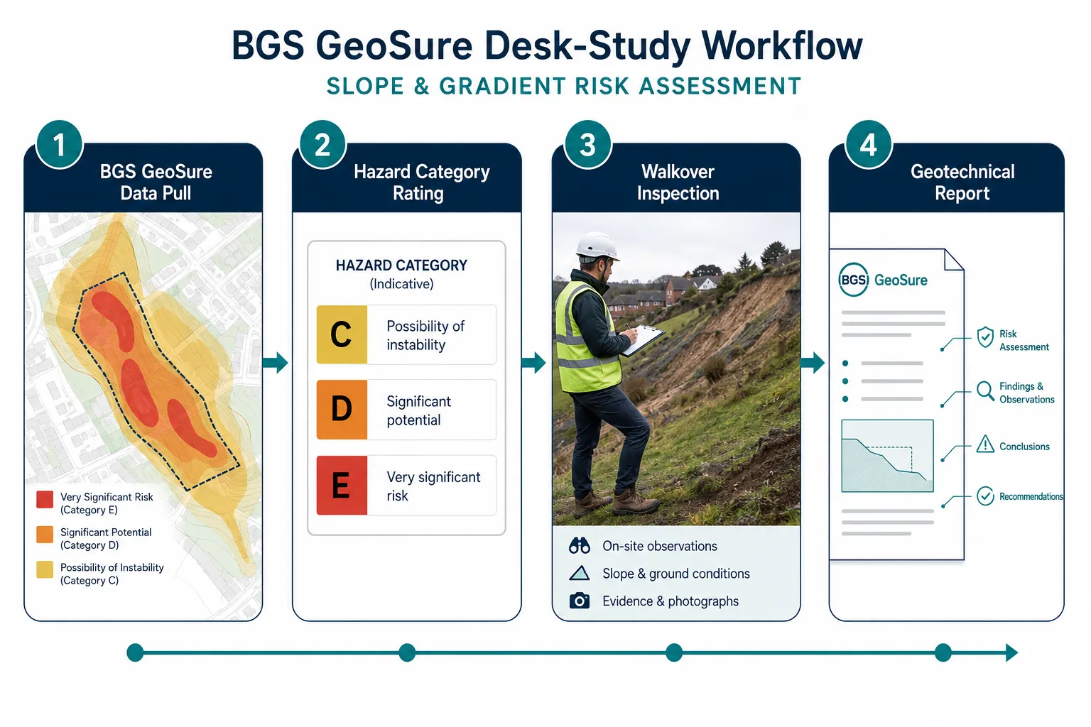
Several forces have driven this change. First, consumer-facing tools now let buyers check slope and subsidence risk before even making an offer. HouseCheckup’s free Ground Stability and Subsidence Risk Check, updated in April 2026, draws directly on BGS GeoSure data to estimate natural ground-movement hazard for any UK address [2][8]. When buyers arrive at a surveyor’s office already holding a GeoSure-based risk rating, they expect the surveyor to interpret it and advise on next steps, not to treat it as news.
Second, climate patterns are amplifying marginal risk. Government land-stability guidance, last updated in July 2026, explicitly flags prolonged wet winters as a trigger for failures on slopes that would otherwise remain stable [7]. Surveyors working across the South East, the Cotswolds escarpment, the North Downs and similar geologies are seeing more instructions where drainage changes or vegetation removal have tipped a borderline site into active movement.
Third, the extension boom has pushed construction onto steeper plots. With permitted development rights encouraging rear and side extensions, many homeowners are loading foundations on sloping ground without understanding the differential settlement risk that follows.
The BGS GeoSure Framework: What Surveyors Are Working With
The GeoSure Ground Stability Data Product (version 8, updated 28 August 2026) identifies multiple hazard processes relevant to sloping sites, including shrink-swell of clays, landslides, collapsible and compressible ground, dissolution features and running sand [8]. The slope-instability layer specifically covers areas susceptible to natural slope movement at 1:50,000 scale, providing complete national coverage for the first time [3][4].
BGS guidance for the general public on home-buying positions natural ground-stability condition reports, which draw on these GeoSure layers, as a core part of a well-informed purchase process wherever slope or subsidence risk is suspected [5]. These reports can quantify hazard beyond what a visual inspection of gradient alone can reveal, because they integrate soil type, moisture regime and geological history alongside topography [5][8].
Hazard categories under the BGS property-hazard framework carry specific consequences:
| Category | Description | Implications for Property |
|---|---|---|
| C | Possibility of slope-instability problems after major changes in ground conditions | Monitor; flag in survey report |
| D | Significant potential for instability with relatively small changes | Specialist assessment recommended before extension or purchase |
| E | Very significant potential; active landslides possible | New build requires slope-stability assessment; special design may be needed; construction may not be possible on active landslides; probable insurance and mortgage implications [12] |
Surveyors working in areas such as Chartered Surveyors Godalming or Chartered Surveyors Leatherhead, where Greensand and Gault Clay geology creates genuine landslide susceptibility, will recognise these categories from live instructions.
How UK Surveyors Assess Gradient Risk: The Step-by-Step Process
Understanding Slope and Foundations: How UK Surveyors Assess Gradient Risk Before You Buy or Extend a Property in practice means following a structured workflow that moves from desk study through to, where necessary, intrusive investigation. Government guidance on land stability is explicit that a slope-stability risk assessment must cover: factors influencing stability, whether the site is currently stable, potential threats from outside the site boundaries, the effect of proposed development, and appropriate mitigation measures [7]. It must be prepared by an appropriately qualified person, a chartered surveyor, geotechnical engineer or engineering geologist [7].
Stage 1: Desk Study
The desk study is the foundation of any gradient risk assessment. It typically includes:
- BGS GeoSure data review, pulling the slope-instability, shrink-swell and landslide layers for the specific address and its surrounding catchment [8]
- Historical mapping, checking Ordnance Survey historical maps for evidence of past earthworks, quarrying, landfill or drainage changes that may have destabilised slopes
- Geological mapping, identifying the solid and drift geology to understand whether clay-rich soils, made ground or soluble rock are present beneath the slope
- Hydrological review, assessing watercourse proximity, soakaway locations and any known drainage issues that could increase pore-water pressure on sloping ground
- Planning history, reviewing any prior slope-stability assessments, geotechnical reports or enforcement notices held by the local authority
Specialist firms undertaking this work combine site history, geology, hydrology and records of past landslides to build a complete picture before visiting the site [11]. The BGS public services portal allows surveyors and engineers to obtain site-specific natural ground-stability condition reports that incorporate these GeoSure layers for any UK property [5].
Stage 2: Walkover Survey and Visual Inspection
NHBC Standards require a walkover survey on all sites as part of the initial investigation, with the scope of further investigation determined by what hazards are identified [13]. For sloping sites, a chartered surveyor or engineering geologist conducting a walkover will look for:
- Tension cracks in the ground surface, driveways or retaining walls running parallel to the slope contour, a classic early sign of rotational slip
- Bulging or bowing at the toe of slopes, retaining walls or embankments
- Uneven or hummocky ground indicating past shallow slip or creep
- Leaning or displaced trees and fence posts, a reliable indicator of slow soil movement
- Wet seepage zones at the base of slopes, particularly on clay-over-permeable-rock interfaces
- Distortion in the structure, stepped or diagonal cracking in masonry, out-of-plumb walls, sticking doors and windows on the downslope elevation
The walkover also assesses retaining walls: their construction type, visible condition, drainage provision (weep holes, land drains), surcharge loading from above and any signs of overturning or sliding failure.
Stage 3: Intrusive Investigation (Where Required)
Where the desk study or walkover identifies potential hazards, NHBC Standards call for a detailed investigation [13]. This may include trial pits to expose foundation bearing conditions, borehole drilling to determine soil stratigraphy and groundwater levels, and laboratory testing of soil samples for shear strength and plasticity index. Specialist firms use advanced software to model slope stability numerically, providing factor-of-safety calculations that inform foundation design and extension feasibility [11].
For buyers considering choosing the right property survey, it is worth noting that a standard Level 2 HomeBuyer Report will flag visible signs of slope movement but will not include geotechnical investigation. A Level 3 building survey is the minimum appropriate product for any property on a significant gradient, and even that may need to be supplemented by a specialist geotechnical report where GeoSure data indicates Category D or E risk.
Foundations on Sloping Sites: Design, Retaining Walls and Drainage
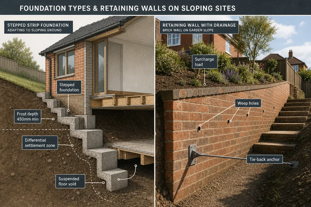
The structural implications of gradient risk are most acutely felt in foundation design. Standard strip foundations, designed for level ground, perform poorly on slopes because differential settlement, where one part of the foundation moves more than another, generates bending stresses that masonry cannot absorb without cracking. NHBC Standards addressing raft, pile, pier and beam foundations on sloping sites require the design to account for site layout, shape, size, levels and potential differential settlement, with stepped foundations and suspended floors flagged as common solutions [13].
Key foundation principles for sloping sites:
- Stepped strip foundations follow the slope in discrete horizontal steps rather than a continuous inclined plane, ensuring each section bears at a consistent depth into stable ground. NHBC Standards stipulate that foundation depth in frost-susceptible ground must be at least 450 mm below finished ground level [13].
- Raft foundations spread load across a larger area and can tolerate moderate differential movement, but require careful structural design on slopes where subsoil variability is high.
- Piled foundations transfer load to deeper, more stable strata, bypassing near-surface unstable soils entirely. They are the preferred solution in Category D and E BGS hazard zones where shallow soils are susceptible to movement [12].
- Suspended floors are specified where the ground beneath the floor slab is subject to heave (from shrink-swell clays) or where the slope creates a significant level difference between the front and rear of the building.
Retaining Walls: A Frequently Underestimated Risk
Retaining walls are among the most commonly under-surveyed elements on sloping residential plots. A wall holding back two metres of soil exerts substantial lateral earth pressure, and if drainage behind the wall is blocked, hydrostatic pressure from waterlogged fill can be catastrophic. Surveyors assessing gradient risk must evaluate:
- Wall type and construction, mass concrete, brick, block, timber or proprietary systems each have different failure modes
- Drainage provision, the presence and condition of weep holes, filter drains or land drainage systems
- Surcharge loading, whether vehicles, structures or stockpiled materials are placed within the failure wedge behind the wall
- Age and maintenance history, older walls built without modern drainage standards are disproportionately represented in failure statistics
Government land-stability guidance specifically warns against undercutting slopes or placing large amounts of material on slopes without technical advice, and recommends controlling water entering the ground from leaks or soakaways [7]. Both of these activities are common during domestic extensions, exactly the moment when retaining wall stability needs to be re-evaluated.
A drainage survey is a valuable companion to a slope-stability assessment, since blocked or misdirected drainage is one of the most frequent triggers for slope movement on residential plots.
Party Wall Considerations on Sloping Ground
Extensions on sloping plots frequently engage the Party Wall etc. Act 1996, particularly where excavation is required within three or six metres of a neighbour’s foundations. On sloping sites, the geometry of the excavation influence zone is more complex than on flat ground, and the risk of undermining neighbouring foundations is higher where the ground falls away toward the shared boundary. Surveyors handling these instructions should review the complete workflow for UK party wall surveyors on complex terraced house projects for guidance on managing these scenarios systematically.
Cost, Valuation and Mortgage Implications of Slope Risk
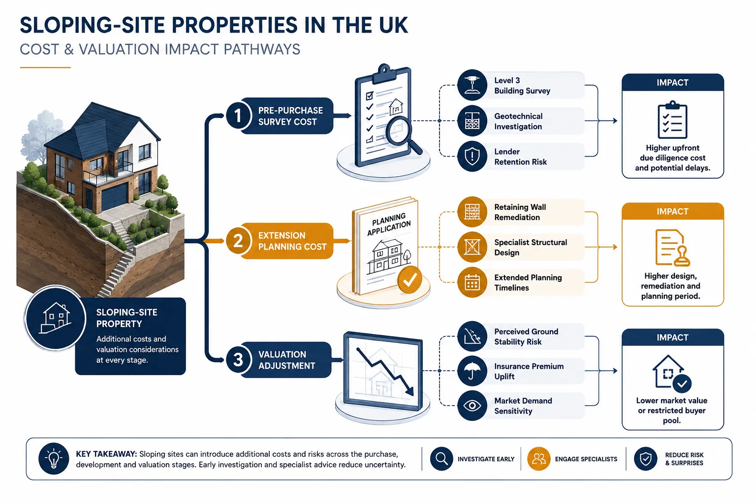
Slope and Foundations: How UK Surveyors Assess Gradient Risk Before You Buy or Extend a Property is not merely a technical exercise, it has direct financial consequences that affect buyers, lenders and insurers alike.
Survey and Investigation Costs
The cost of gradient risk assessment scales with the complexity of the site and the level of investigation required. A desk-based GeoSure screening is inexpensive and can be obtained through BGS public services [5]. A Level 3 building survey that includes detailed slope assessment will typically cost more than a standard survey; for a guide to structural survey pricing, buyers should obtain quotes from RICS-regulated firms. Where intrusive investigation is required, trial pits, boreholes, laboratory testing, costs rise substantially, and a specialist geotechnical report may be needed in addition to the building survey.
Valuation Adjustments and Mortgage Retention
Mortgage lenders treat slope instability as a material risk. Where a valuer identifies BGS Category D or E conditions, or visible signs of active movement, lenders may:
- Decline to lend on properties with active landslide risk
- Apply a retention, withholding a portion of the mortgage advance until remediation works are completed and certified
- Require a specialist report as a condition of offer, delaying completion
Surveyors providing property certification for lenders must ensure their reports adequately address gradient risk, particularly in light of the RICS professional standard on environmental risks. Failure to flag material slope instability can expose surveyors to professional negligence claims, a risk discussed in detail in the context of mortgage lender valuation audits and professional negligence protection in 2026.
Insurance Premium Uplift
BGS guidance explicitly notes that Category D and E hazard ratings carry probable or significant increases in insurance risk, and advises property owners to inform their insurers and mortgage lenders if active landsliding appears near the property [12]. Buyers who discover post-purchase that their property sits in a high-hazard zone may find standard buildings insurance unavailable or subject to significant premium loading and exclusions.
Impact on Extension Feasibility
Planning authorities are increasingly applying government land-stability guidance when determining applications for extensions on sloping sites [7]. Where a site falls within a known landslide-susceptible area, a slope-stability risk assessment prepared by a qualified professional may be required as a planning condition. The assessment must address the effect of the proposed development on stability and propose appropriate mitigation [7]. Extensions that require significant cut-and-fill earthworks, new retaining walls or drainage re-routing on Category D or E sites may face refusal or substantial additional engineering costs.
“Where hazards are identified or suspected, such as slope instability, compressible or shrink-swell soils, detailed investigation and engineer-designed foundations are required, rather than relying on standard strip foundations.”, NHBC Standards guidance on sloping sites [13]
Mitigation Measures: What Surveyors Recommend
When gradient risk is identified, the surveyor’s role shifts from assessment to recommendation. Standard mitigation advice for sloping residential sites includes:
- Drainage management, installing or maintaining land drains, French drains and soakaways to prevent pore-water pressure build-up in slope soils
- Vegetation management, maintaining tree and shrub cover on wooded slopes to enhance root reinforcement and reduce surface runoff, while avoiding large-scale clearance that removes root cohesion [7]
- Retaining wall repair or replacement, installing adequate weep holes, filter drains and, where necessary, structural tie-backs or ground anchors
- Foundation underpinning or piling, where existing foundations are shown to be inadequate for the slope conditions, underpinning or replacement with a piled system may be required
- Monitoring, installing crack monitors on walls or slope markers in the ground to track any ongoing movement before and during construction
Surveyors in areas with known slope instability, including parts of Chartered Surveyors Bromley and Chartered Surveyors Epsom where London Clay and Thanet Sand interfaces create classic rotational slip conditions, will often recommend a monitoring period before advising clients to proceed with an extension.
Conclusion: Actionable Next Steps for Buyers and Homeowners
Gradient risk is no longer a specialist footnote in a building survey, it is a core due-diligence requirement with direct implications for foundation design, planning consent, mortgage availability and insurance. The following steps summarise what buyers and homeowners should do in 2026:
Run a free BGS GeoSure check on any property before making an offer. Tools such as HouseCheckup’s Ground Stability and Subsidence Risk Check [2] provide an immediate indication of whether the site falls within a slope-instability hazard zone.
Commission a Level 3 building survey for any property on a noticeable gradient, or where GeoSure data indicates Category C risk or above. Understand the difference between a Level 2 and Level 3 survey before instructing a surveyor.
Request a specialist geotechnical report where the desk study or walkover identifies Category D or E conditions, visible signs of slope movement, or where an extension requiring significant earthworks is planned.
Engage a chartered surveyor early in the planning process for any extension on a sloping plot. Slope-stability assessments are a planning requirement in many cases [7], and early engagement avoids costly redesign after planning submission.
Notify insurers and mortgage lenders if active landsliding or significant slope movement is identified near the property, as BGS guidance explicitly recommends [12].
Do not rely on standard strip foundations on sloping ground without engineer confirmation that ground conditions support them. Stepped foundations, piled solutions or suspended floors are frequently required and should be budgeted for from the outset [13].
Slope and ground stability are issues where early, well-informed professional advice consistently saves buyers and homeowners from far greater costs later. Engaging a RICS-regulated chartered surveyor with experience in gradient risk assessment is the single most effective step any buyer or developer can take before committing to a sloping site.
References
[2] Ground Stability – housecheckup.co.uk
[3] Geosure Slope Instability2 – data.gov.uk
[4] Geosure Landslides Slope Instability Version 8 – data.gov.uk
[5] Public – bgs.ac.uk
[7] Land Stability – gov.uk
[8] Geosure Ground Stability Data Product Version 8 – data.gov.uk
Related services from Canterbury Surveyors
- Party wall surveyors in Canterbury & Kent
- Boundary surveys
- RICS property valuations
- RICS Homebuyer Surveys (Level 2)
Get a fixed-fee quote or call 0204 579 8270.