
Canterbury & Kent
Location in UK Property Valuation: From Flood Risk to Subsidence and Noise, What Surveyors Really Check
Roughly 6.8% of UK properties currently sit in high flood-risk categories, and under a high-emissions climate scenario that figure could climb to 9.6% [3]. Yet many buyers still treat location as little more than a postcode preference. For a chartered surveyor, location is a forensic exercise: a structured analysis of environmental hazards, ground conditions, noise exposure, planning constraints and insurance availability that can shift a property’s market value by tens of thousands of pounds in either direction.
This guide unpacks exactly what surveyors examine when they assess location in UK property valuation: from flood risk to subsidence and noise, what surveyors really check, and why those checks matter far more than most buyers realise.
Key Takeaways
- Flood-exposed homes sell at an average 8.1% discount, rising to roughly 32% for the highest-risk properties, and UK residential property may be collectively overvalued by around £20 billion because flood risk is not yet fully priced in [6][9].
- Subsidence risk, driven by clay soils, tree proximity and drainage failures, is a core locational factor that surveyors cross-reference with geological maps and ground-movement data.
- Road noise, flight paths and proximity to commercial or industrial uses are assessed as environmental nuisances that affect both marketability and achievable price.
- RICS valuation frameworks updated in 2025-2026 require surveyors to document how location-specific hazards, including coastal erosion and ground instability, have informed their valuation assumptions [4].
- Buyers and lenders should treat a full assessment of valuation factors as essential due diligence, not an optional extra.
How Flood Risk Has Become a Core Valuation Variable
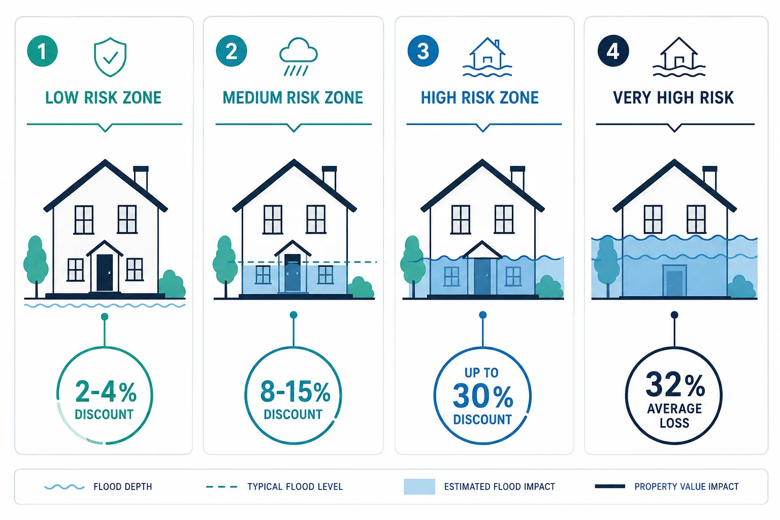
The relationship between flood exposure and property value is no longer speculative. Large-scale UK transaction data show that flood-exposed homes sell at an average 8.1% discount, with the steepest losses, around 32%, recorded for properties in the highest-risk bands [6][8]. A January 2026 analysis found that each 1 percentage point increase in modelled flood probability is associated with a 0.07-0.11% reduction in asking and achieved prices, meaning cumulative discounts compound quickly as risk rises [1].
Loughborough University research published in June 2026 adds a long-term dimension: homes that have actually flooded lose roughly 3% of their value immediately after the event, but the loss deepens to around 10% after 15 years. Across the affected sample, that equates to an estimated £5.6 billion in aggregate value destruction, or approximately £43,347 per property [2].
Why do surveyors treat flood risk as a primary location factor?
Because lenders do. Barclays disclosed in February 2026 that 2.6% of its UK mortgage book sits in high flood-risk areas and 1.2% in very high-risk zones, explicitly warning that increasing flooding “has the potential to impact the valuation of properties directly” and indirectly through falling local demand [7]. When a major lender flags a location risk in its own accounts, surveyors are expected to reflect that risk in their reports.
How Surveyors Translate Flood Probability into Price Adjustments
RICS-compliant valuers do not simply note that a property is near a river. They map the site against the Environment Agency’s official flood-risk bands, which categorise properties by annual flood probability from rivers, the sea and surface water. The practical price implications, based on specialist valuation commentary from early 2026, are broadly as follows:
| Flood Risk Band | Approximate Annual Probability | Typical Price Discount |
|---|---|---|
| Low | Below 0.1% (1 in 1,000) | Negligible to 2% |
| Medium | 0.1% to 1% (1 in 1,000 to 1 in 100) | 2-4% |
| High | 1% to 3.3% (1 in 100 to 1 in 30) | 8-15% |
| Very High | Above 3.3% (greater than 1 in 30) | 15-32%+ |
Properties in the 80-90% flood-probability band face discounts of around 15%, while those above 90% can see reductions approaching 30% [1][10]. Land within designated flood zones typically sells for 20-30% less than comparable plots outside risk areas [1].
Critically, surveyors must also consider insurance availability. Where the Flood Re scheme applies, buyer perception of risk may be partially offset by accessible insurance premiums, but Flood Re does not cover all property types, and its long-term future is not guaranteed [10][12]. A surveyor who ignores insurance availability when commenting on marketability is producing an incomplete report.
“UK residential properties may collectively be overvalued by around £20 billion because flood risk is not yet fully priced into current valuations.” [9]
A 2026 study by PriceHubble and MIAC Analytics warns that flooding and subsidence together could cut London property values by up to 31% [3]. For buyers in the capital and across flood-prone regions, commissioning a building survey that identifies risks in the current market is not a luxury, it is a financial safeguard.
Subsidence, Ground Stability and Geological Risk
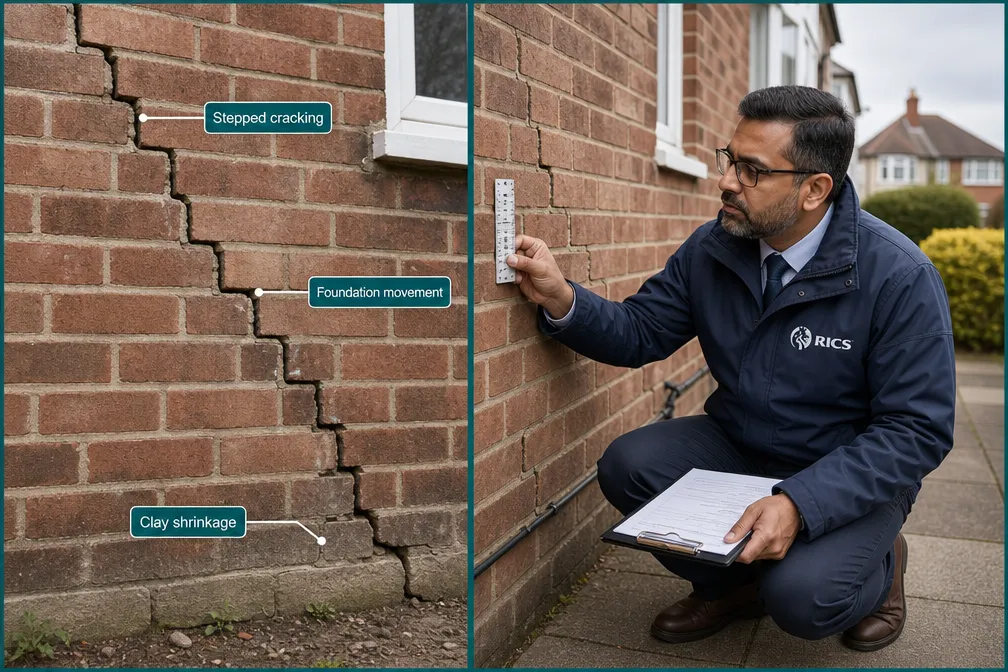
Subsidence is the downward movement of ground beneath a building, and it is one of the most consequential location-based risks a surveyor can identify. Unlike flood risk, which is largely governed by proximity to water bodies, subsidence risk is determined by soil type, drainage history, tree proximity and the age of the building’s foundations.
The key geological triggers surveyors look for include:
- Shrinkable clay soils, London Clay and other high-plasticity clays expand when wet and shrink when dry, causing seasonal ground movement that stresses foundations.
- Made ground and infill, Properties built on former industrial land, landfill or backfilled excavations are inherently unstable.
- Mining legacy, In former coalfield areas across the Midlands, South Wales and parts of Yorkshire, historic mine workings can cause sudden or gradual ground settlement.
- Tree root systems, Large trees within 10-15 metres of a building can extract moisture from clay soils, accelerating shrinkage beneath foundations.
- Drainage failures, Leaking drains soften clay soils and wash away granular fill, undermining foundations from below.
Surveyors cross-reference site observations with the British Geological Survey’s (BGS) digital geological maps and subsidence susceptibility datasets. Where a property sits on a high-risk substrate, the surveyor will document visible symptoms, stepped diagonal cracking in brickwork, distorted door frames, uneven floors, and recommend specialist investigation before exchange.
The valuation impact of confirmed subsidence is severe. Mortgage lenders will typically require a structural engineer’s report and may impose retention conditions or decline to lend entirely until remediation is complete. Even where subsidence has been repaired and monitored, some insurers impose higher premiums or excesses, which suppresses buyer demand and achievable price.
The PriceHubble and MIAC Analytics study cited above specifically names subsidence alongside flooding as a combined threat capable of cutting London values by up to 31% [3]. For properties in areas with known geological sensitivity, a Level 3 building survey is the appropriate starting point for any buyer seeking to understand the true risk profile of a location.
The Three-Metre Rule and Neighbouring Structures
Ground stability is not only about what lies beneath the subject property. Where a proposed purchase is close to a neighbouring building or boundary, the three-metre rule under the Party Wall Act becomes relevant. Excavation or construction within three metres of an existing structure at a depth below the existing foundations can trigger statutory obligations and, if mishandled, cause structural damage that affects both properties’ values.
Noise, Environmental Nuisances and Planning Risk: What Surveyors Really Check
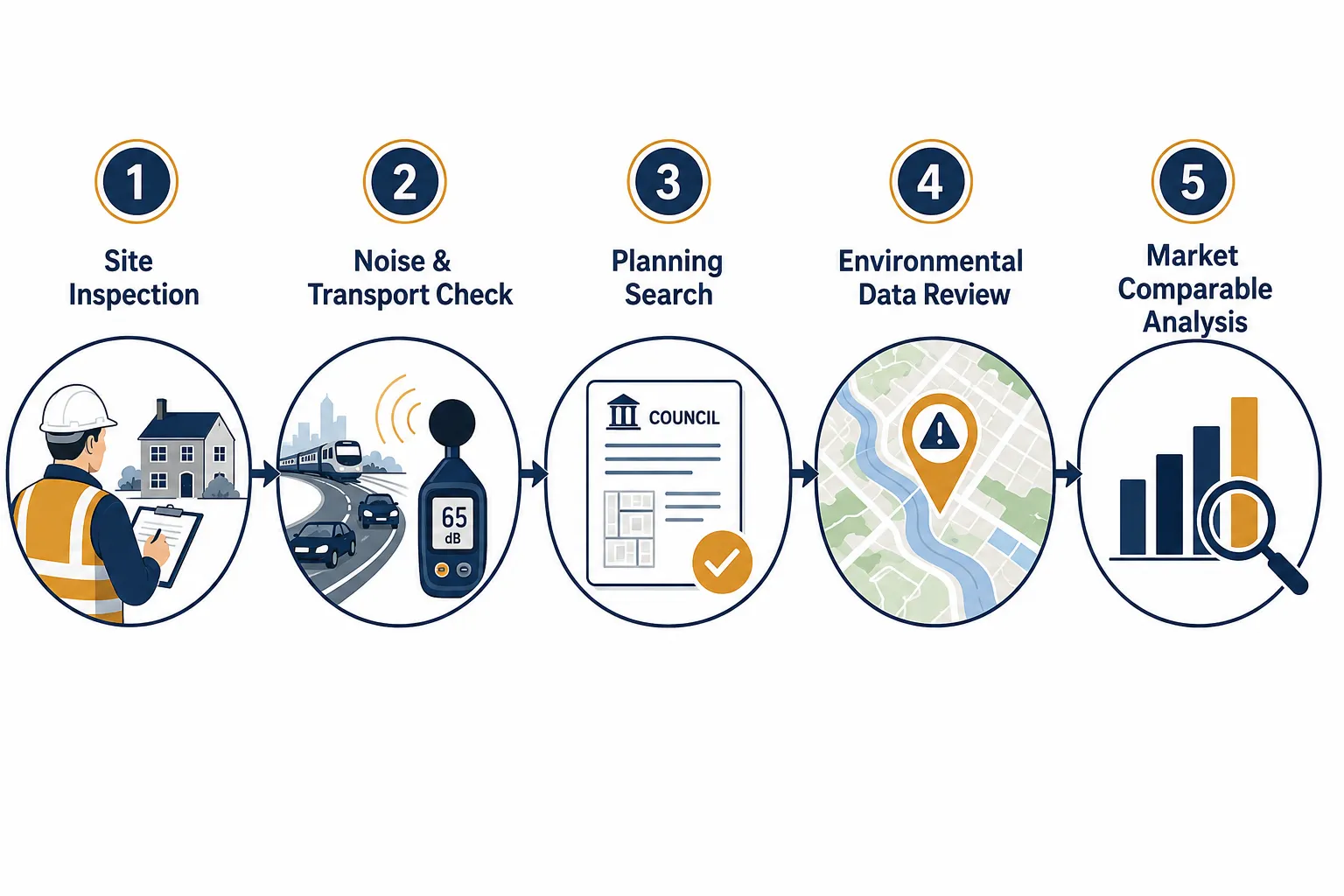
Flood risk and subsidence attract the most attention in valuation commentary, but experienced surveyors working on location in UK property valuation: from flood risk to subsidence and noise, what surveyors really check, give equal weight to a cluster of environmental and planning factors that are less dramatic but equally capable of suppressing value.
Road and Transport Noise
Road noise is one of the most consistently underestimated valuation factors. Properties within 50 metres of a heavily trafficked A-road, or beneath a flight path in the approach corridor to a major airport, face measurable price penalties. Hedonic pricing studies consistently show that each decibel increase in ambient noise above a threshold of around 50 dB(A) reduces residential values by approximately 0.5-1.5%, depending on the market and property type.
Surveyors assess noise exposure by:
- Reviewing the site’s position relative to mapped noise contours (available from local authorities under the Environmental Noise Directive).
- Conducting a site visit at different times of day where feasible.
- Noting the orientation of habitable rooms, a bedroom facing a dual carriageway is a material factor.
- Checking whether double or secondary glazing has been installed as mitigation, and whether this affects ventilation or character.
Proximity to Commercial, Industrial and Utility Infrastructure
A property adjacent to a waste transfer station, electricity substation, mobile phone mast or major sewage works faces both amenity and perception challenges. Even where there is no proven health risk, buyer resistance suppresses demand and price. Surveyors note these features in their location commentary and consider whether they are reflected in the comparable evidence used to support the valuation.
For commercial property valuations, proximity to industrial uses can cut both ways, it may be a positive for logistics or trade premises but a negative for mixed-use or residential conversion schemes.
Planning Constraints and Permitted Development Rights
Location-based planning risk is a factor that many buyers overlook until after exchange. Surveyors and valuers check:
- Conservation area status, Restricts external alterations and permitted development rights, limiting the scope for extensions or alterations that would add value.
- Listed building designation, Imposes significant maintenance obligations and restricts internal as well as external works.
- Article 4 Directions, Remove specific permitted development rights in defined areas, often preventing conversion of houses to HMOs or offices to residential.
- Proximity to proposed developments, A large residential or commercial scheme nearby can affect outlook, traffic, and local amenity both during construction and after completion.
- Flood zone planning restrictions, Properties in Flood Zone 3 face restrictions on new development and change of use, which can limit future value uplift.
RICS valuation frameworks updated in 2025-2026 explicitly require valuers to comment on location-specific issues affecting value, listing factors including coastal erosion and brine extraction, and stating that “any other matters which affect value” should be reported [4]. In practice, this means surveyors are professionally obligated to flag noise, planning constraints and environmental nuisances, not merely physical defects.
Japanese Knotweed and Invasive Species
Japanese knotweed is a location-specific risk that sits at the intersection of ground condition and planning. Its presence within seven metres of a structure can affect mortgage availability, and its classification under RICS protocols requires specific disclosure. For properties where knotweed has been identified or treated, a Level 3 building survey following RICS protocols is essential to establish the extent of the risk and any valuation adjustment required.
How RICS Standards Shape Location-Based Valuation Reporting
The RICS Home Survey Standard (2nd Edition) and the updated site notes and valuation reasoning framework published in 2025 formalise the expectation that surveyors document climate-related and environmental hazards as part of every valuation and survey report [4]. The framework requires surveyors to explain how location risks have informed their valuation assumptions and to identify any limitations on marketability arising from those risks.
This is a significant shift from earlier practice, where location commentary was often brief and formulaic. Under current standards, a surveyor who fails to reference flood-zone classification, ground stability data or material planning constraints in a report covering a property in an affected area is potentially in breach of professional obligations.
For buyers navigating this landscape, working with local chartered surveyors who have genuine knowledge of the specific area, its flood history, soil conditions, noise environment and planning pressures, is far more valuable than a generic desktop report.
The Role of Climate Risk in Forward-Looking Valuations
The 2026 research environment has made clear that location risk is not static. Climate projections indicate that the proportion of UK properties in high flood-risk categories could rise from 6.8% to 9.6% under a high-emissions scenario [3]. Surveyors instructed on properties in coastal or riverside locations are increasingly expected to comment not only on current risk but on how that risk profile may change over a typical mortgage term of 25 years.
Academic hedonic pricing work published in January 2026 found an average discount of approximately 2.21% for properties in high flood-risk areas, but also noted that where Flood Re is in place, the market impact can be partially muted, indicating that surveyors must weigh insurance availability alongside raw hazard metrics [10]. For valuation accuracy in markets where sentiment is shifting, this nuanced approach to location risk is increasingly what separates a reliable report from a superficial one.
Conclusion
Location in UK property valuation: from flood risk to subsidence and noise, what surveyors really check, is a far more rigorous discipline than most buyers appreciate. The evidence is unambiguous: flood-exposed properties face average discounts of 8.1%, rising to 32% in the highest-risk bands [6][8], and the UK residential market may be collectively overvalued by £20 billion because these risks are not yet fully priced in [9]. Subsidence, ground instability, road noise, planning constraints and environmental nuisances compound these effects and can materially affect both achievable price and mortgage availability.
Actionable next steps for buyers, sellers and investors:
- Commission a Level 3 Building Survey before exchange on any property in a flood zone, on clay soils, near large trees, or adjacent to major transport infrastructure. A thorough survey will document all location-based risks in a RICS-compliant format.
- Check the Environment Agency’s flood map for the specific property address and understand which flood-risk band applies, not just the general postcode area.
- Request a planning search through your solicitor and ask your surveyor to comment on any Article 4 Directions, conservation area restrictions or nearby development proposals.
- Verify insurance availability and cost before exchange, particularly for properties in Flood Zone 2 or 3. Uninsurable or high-premium properties face structural demand challenges that affect long-term value.
- Engage a surveyor with local knowledge, someone who knows the flood history, soil conditions and planning environment of the specific area, not just the national data.
For specialist advice on location-based valuation factors across London and the South East, Canterbury Surveyors provide RICS-compliant surveys and valuations tailored to the specific risk profile of each property and location.
References
[1] Does Flood Risk Affect House Prices – unda.co.uk
[2] Flood Hit Homes – lboro.ac.uk
[3] Flooding And Subsidence Could Cut London Property Values By Up To 31 Study Warns – theintermediary.co.uk
[4] Site Notes And Valuation Reasoning Offices 2025 – rics.org
[6] Residential Property Flood Risk Uk 2023 – bayes.citystgeorges.ac.uk
[7] claimsjournal – claimsjournal.com
[8] eurekalert – eurekalert.org
[9] Escalating Flood Risks Mean Uk Properties Are On Track To Be Overvalued By 20 Billion – hometrack.com
[10] Rising Flood Risk 5 Key Meanings For The Future Of Uk Property Market And Regulation – climate-x.com
Related services from Canterbury Surveyors
- Party wall surveyors in Canterbury & Kent
- Boundary surveys
- RICS property valuations
- Building Surveys (Level 3)
Get a fixed-fee quote or call 0204 579 8270.