
Canterbury & Kent
Location in UK Property Valuation: How Surveyors Use ‘Location’ Data Beyond Estate Agent Marketing
“
A two-bedroom flat described as being in a “highly sought-after location close to excellent transport links” can sit inside a Flood Zone 3 designation, fall outside the catchment boundary of the school mentioned in the brochure, and back onto a commercial noise source that no marketing copy mentions. For a chartered surveyor, that gap between marketing language and measurable location data is precisely where professional judgement earns its value. Understanding Location in UK Property Valuation: How Surveyors Use ‘Location’ Data Beyond Estate Agent Marketing is not just a technical exercise, it is the difference between a defensible, evidence-based opinion of value and a figure that may not survive lender scrutiny or legal challenge.
Key Takeaways
- Estate agent descriptions of “location” are marketing tools; surveyors replace vague language with verified, quantifiable data from sources such as HM Land Registry, the Environment Agency, and RICS market surveys.
- From 28 August 2026, HM Land Registry Price Paid Data will include Unique Property Reference Numbers (UPRNs), enabling surveyors to link individual sale records to flood risk, planning, and transport datasets at property level.
- RICS UK Residential Market Survey data provides regional and sub-regional sentiment indicators that help valuers calibrate whether a specific neighbourhood is strengthening or softening relative to the national picture.
- Environmental risks, flood zones, ground stability, noise, and air quality, carry measurable value impacts that must be disclosed and quantified in formal RICS-compliant valuations.
- The growing proptech sector, estimated at USD 2.49 billion in 2024 and projected to reach USD 13.12 billion by 2035, is expanding the tools available to surveyors, but a persistent data-literacy gap means professional interpretation remains essential.
Why “Location” Means Something Different to a Surveyor
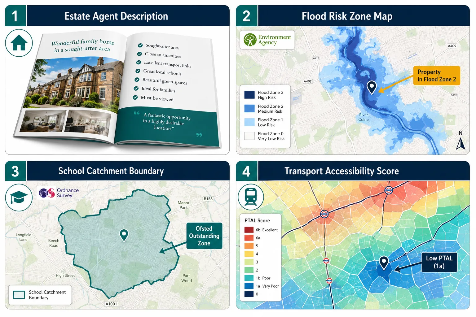
Estate agents use location as a selling point. Surveyors use it as an evidence category. The distinction matters because a formal RICS valuation must be evidence-based, follow strict regulatory guidelines, and rely on comparable transactions rather than asking prices or marketing language [7]. When a surveyor writes about location in a Red Book valuation report, they are documenting a structured set of measurable attributes, each of which can add or subtract value independently.
Those attributes fall into several distinct groups:
Physical and environmental characteristics
- Flood risk designation (Environment Agency Flood Zones 1, 2, and 3)
- Ground stability and subsidence history
- Proximity to contaminated land or former industrial sites
- Noise exposure levels (road, rail, aircraft, commercial)
- Air quality index data
Connectivity and accessibility
- Public Transport Accessibility Level (PTAL) scores
- Walking distance to rail and underground stations (measured, not estimated)
- Road network access and proximity to motorway junctions
- Cycling infrastructure ratings
Planning and policy constraints
- Green Belt, Conservation Area, or Area of Outstanding Natural Beauty designations
- Article 4 Directions restricting permitted development
- Proximity to listed buildings and their curtilages
- Local Plan allocations and housing land supply position
Socioeconomic and amenity factors
- School catchment boundaries and Ofsted ratings for catchment schools
- Crime statistics at Lower Super Output Area level
- Retail and employment centre accessibility
- Regeneration zone designations and infrastructure investment pipelines
Each of these data points can be cross-referenced against sold-price evidence to establish a measurable premium or discount. That process is fundamentally different from describing a property as being in a “vibrant neighbourhood.” For a deeper look at the full range of factors that feed into a formal opinion of value, the valuation factors resource provides a useful reference point.
“Historic Price Paid Data is evidence of transactions, not a direct valuation of a specific property, reinforcing surveyors’ role in adjusting for micro-location, condition, and market timing.” [15]
How Surveyors Collect and Interpret Granular Location Data

The data infrastructure available to UK surveyors has changed significantly in 2026. From 28 August 2026, HM Land Registry’s monthly Price Paid Data will include Unique Property Reference Numbers (UPRNs) and INSPIRE IDs in separate lookup tables [3]. This single change allows a surveyor to link an individual sold-price record to flood risk designations, planning history, EPC ratings, and transport accessibility scores, all at the level of a specific property rather than a postcode average.
What UPRNs enable in practice:
| Data Layer | Source | Location Insight Gained |
|---|---|---|
| Sold price history | HM Land Registry PPD | Micro-comparable evidence within streets |
| Flood risk zone | Environment Agency | Zone 1/2/3 designation per property |
| EPC rating | MHCLG register | Energy performance and retrofit liability |
| Planning history | Local Authority portal | Past consents, enforcement notices |
| School catchment | Local Authority GIS | Precise in/out catchment status |
| PTAL score | TfL / regional equivalents | Transport accessibility score |
One proptech platform now aggregates 19.4 million searchable properties across England and Wales, combining EPC ratings, flood risk, sold prices, and planning data into a single structured record per home [15]. Surveyors can use such platforms as a starting point for comparable selection, but the professional obligation remains to adjust for micro-location differences, condition, and market timing that automated models cannot replicate [7].
The UK House Price Index, produced jointly by HM Land Registry and other bodies, provides indices by country, region, and local authority [6]. A January 2026 HPI update reported average UK prices falling 0.3% between December 2025 and January 2026 [9], a national figure that conceals wide local variation. Surveyors working in resilient northern cities face a different adjustment task from those valuing properties in more volatile London sub-markets [6][9]. Chartered surveyors in Surrey and chartered surveyors in Sussex operate in markets where micro-location premiums, for school catchments, coastal proximity, and commuter-belt transport links, can be substantial and must be evidenced rigorously.
Government pilots running through March 2026 are testing new location-data solutions with local authorities and developers, aiming to integrate planning, infrastructure, and geospatial data into digital planning and property tools [5]. These pilots are expected to further expand surveyors’ ability to quantify the value impact of future transport schemes or regeneration projects within formal valuations over the coming years [5].
RICS Market Data and the Regional Dimension of Location in UK Property Valuation
A common misconception is that RICS market surveys are only relevant to national price trend commentary. In practice, they are a core tool for Location in UK Property Valuation: How Surveyors Use ‘Location’ Data Beyond Estate Agent Marketing at the sub-regional level.
RICS UK Residential Market Survey data through 2026 reveals how surveyors track location-sensitive market sentiment, not just prices [1][4]. In April 2026, the new appraisals measure fell to a net balance of -16%, indicating a weakening pipeline of future listings [1]. By July 2026, market appraisals relative to a year earlier had recovered to +19%, signalling stronger valuation and listing activity across many areas [4]. These headline figures, however, mask sharp regional divergence.
Regional performance patterns in 2026 (illustrative):
- Northern England, Scotland, and Northern Ireland: outperforming national averages on price and activity metrics
- London and the South East: underperforming relative to the national picture, with greater price sensitivity to mortgage rate movements
- Midlands and East of England: broadly tracking national trends with localised pockets of resilience
Surveyors map this regional patterning to calibrate yields and comparables for individual properties [10]. A property in a neighbourhood at an inflection point, poised for regeneration or, conversely, facing economic headwinds, requires a different weighting of comparable evidence than one in a stable, mature market [8][10].
A February 2026 proptech briefing noted that sales and price expectations had reached their best levels since early 2025, with surveyors anticipating higher transaction volumes and modest price rises over the subsequent 12 months [8]. This macro expectation feeds directly into how a valuer interprets the location premium for a property in an area where regeneration investment is confirmed but not yet fully reflected in comparable sales.
For surveyors working on lender instructions, the obligation to demonstrate location-level market evidence is particularly acute. The mortgage lender valuation audits and professional negligence guidance published in 2026 makes clear that inadequate location analysis is a recurring theme in negligence claims.
Environmental Risks: The Location Data Estate Agents Rarely Mention
Of all the location factors that diverge most sharply between marketing copy and surveyor analysis, environmental risk is the most consequential. Flood risk, in particular, carries direct implications for mortgage availability, insurance premiums, and long-term value trajectory.
Flood risk and its valuation impact:
The Environment Agency designates land into three flood zones based on annual probability of flooding from rivers or the sea:
- Zone 1: Less than 0.1% annual probability, minimal impact on value
- Zone 2: Between 0.1% and 1% annual probability, measurable discount, insurance implications
- Zone 3a: Greater than 1% annual probability, significant value impact, potential mortgage restriction
- Zone 3b (functional floodplain): Regular flooding expected, severe value impact, limited lender appetite
A property marketed as “set beside a charming river” may sit in Zone 3a. The surveyor’s job is to identify this, quantify the discount against comparable sales of similar properties outside the flood zone, and disclose it clearly in the report. The valuing homes with historic subsidence or previous structural movement guidance illustrates the same principle applied to ground stability risk.
Other environmental factors surveyors quantify:
- Aircraft noise: Properties under Heathrow, Gatwick, or Stansted flight paths carry measurable discounts that vary by altitude band and frequency of overflights. Chartered surveyors in Hounslow and chartered surveyors in Ealing work with this data routinely.
- Road and rail noise: Noise maps produced under the Environmental Noise Directive provide decibel contours that can be cross-referenced against sold-price evidence.
- Contaminated land: Local authority Part IIA registers and Phase 1 desk studies identify sites with potential contamination liabilities that affect both value and mortgageability.
- Air quality: DEFRA’s UK Air Quality Archive provides modelled annual mean concentrations of key pollutants by location, increasingly relevant as lenders and buyers factor health and ESG considerations into property decisions.
The Data Capability Gap and the Surveyor’s Professional Role
More data does not automatically produce better valuations. An industry survey on the “data capability gap” in real estate, open in mid-2026, highlights that many UK property organisations overestimate their ability to exploit location and other structured data [2]. The survey findings suggest that although more tools are available, a skills gap persists in interpreting granular datasets, UPRNs, linked planning and risk data, within rigorous valuation frameworks [2][7].
This gap is significant for several reasons:
Automated Valuation Models (AVMs) cannot replace professional judgement. AVMs use postcode-level or street-level data and cannot account for the specific orientation, aspect, or micro-location of an individual property. A corner plot with dual road frontage, a flat above a commercial unit, or a house backing onto a railway embankment all require human interpretation.
Proptech tools are concentrated geographically. A 2026 ranking of the top 100 UK proptech companies shows strong clustering in London and the South East, with the South East listed as the second most represented region (11 companies) [11]. Surveyors in major hubs have earlier access to advanced location analytics, while similar capabilities are spreading more slowly to other regions [11].
The proptech market is growing rapidly. The UK proptech sector was estimated at approximately USD 2.49 billion in 2024, with projections of USD 13.12 billion by 2035 [14]. This expansion includes firms specialising in geospatial analytics, automated valuation models, and location risk scoring, all of which are increasingly supplying datasets that valuers can use to supplement traditional RICS-compliant approaches.
The proptech trends for property surveyors in 2026 article explores how agentic AI, VR, and blockchain integration are reshaping the data landscape for valuation professionals. The core principle, however, remains unchanged: technology supplies the data; the chartered surveyor supplies the professional judgement to interpret it within a regulatory framework.
Applying Location Data in Specific Valuation Contexts
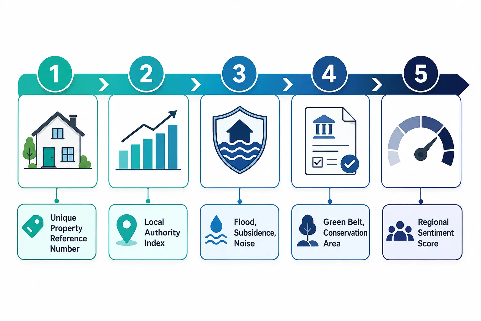
The practical application of location data varies depending on the purpose of the valuation. The same property may require different location analysis depending on whether the instruction is for mortgage security, probate, capital gains tax, or litigation support.
Mortgage security valuations require the surveyor to assess location factors that affect both current market value and the lender’s ability to recover the loan in a distressed sale. Flood risk, planning restrictions, and proximity to commercial uses all affect saleability and therefore lending risk. The Red Book valuation framework sets out the regulatory requirements for this type of instruction.
Probate and capital gains tax valuations require a retrospective assessment of value at a specific historical date. Location data must be sourced as it existed at that date, flood zone designations, school catchment boundaries, and transport infrastructure can all change over time. See the probate valuation and capital gains tax valuation pages for context on these specific requirements.
Expert witness valuations in mortgage disputes or property litigation require the surveyor to demonstrate, in CPR-compliant terms, how location data was sourced, weighted, and applied. The expert witness roles in 2026 mortgage lender disputes guidance illustrates how location analysis must be documented to withstand cross-examination.
Commercial property valuations introduce additional location factors: proximity to labour markets, logistics infrastructure, planning use class restrictions, and footfall data for retail assets. Commercial property surveyors apply the same evidence-based discipline to these more complex location datasets.
Conclusion
The phrase “great location” in an estate agent’s particulars is the beginning of a surveyor’s enquiry, not the end of it. Location in UK Property Valuation: How Surveyors Use ‘Location’ Data Beyond Estate Agent Marketing describes a disciplined, evidence-driven process that replaces vague marketing language with verified, quantifiable data, flood zone designations, UPRN-linked comparable sales, school catchment boundaries, noise contours, and RICS market sentiment indices.
The infrastructure supporting this process is improving rapidly. The addition of UPRNs to HM Land Registry Price Paid Data from August 2026 will make it significantly easier to link individual sale records to wider geospatial and risk datasets [3]. Government proptech pilots are expanding the integration of planning and infrastructure data into digital property tools [5]. And a growing proptech sector is supplying increasingly sophisticated location analytics to valuers across the country [14].
Actionable next steps for property buyers, investors, and professionals:
- Before relying on any estate agent’s location description, request or commission a formal valuation that documents flood risk, planning constraints, and transport accessibility scores as discrete, evidenced items.
- When instructing a surveyor, specify the purpose of the valuation clearly, the location data required for a mortgage security report differs from that needed for a probate or litigation instruction.
- If purchasing in a market where regional performance diverges from the national picture, ask the surveyor to reference RICS UK Residential Market Survey data for the specific region and sub-market.
- For investment decisions in areas with confirmed regeneration or infrastructure investment, ensure the valuation explicitly addresses how future location improvements have or have not been reflected in current comparable evidence.
- Engage a RICS-qualified chartered surveyor with demonstrable local market knowledge, the ability to interpret granular location data within a specific sub-market remains a human skill that no automated model can fully replicate.
References
[1] UK Residential Survey April 2026 – rics.org
[2] The Data Capability Gap Perception Vs Reality In Real Estate Technology Industry Survey – ukproptech.com
[3] Land Registry – gov.uk
[4] UK Residential Survey July 2026 – rics.org
[5] Proptech – mhclgdigital.blog.gov.uk
[6] UKHPI – landregistry.data.gov.uk
[7] What Is A RICS Valuation A Professional Guide To Property Valuations 2026 – winfieldssurveyors.co.uk
[8] Proptech Briefing February 2026 Michael Bristow – linkedin.com
[9] Land Registry January 2026 HPI – linkedin.com
[10] Valuation Confidence Boosters Using RICS Real Time Data Countering Macro Uncertainty In Spring 2026 Transactions – princesurveyors.co.uk
Related services from Canterbury Surveyors
- Boundary surveys
- Building expert witness surveyors
- RICS property valuations
- Structural engineers in Canterbury & Kent
Get a fixed-fee quote or call 0204 579 8270.