
Canterbury & Kent
Place Matters: How ‘Place’ Characteristics Influence UK Building Surveys and Mortgage Valuations
Industry analysis consistently attributes 60 to 80 percent of a residential property’s market value to its location and the characteristics of the area surrounding it rather than to the physical fabric of the building itself. Yet many buyers treat a building survey and a mortgage valuation as purely technical exercises focused on bricks, mortar, and roof tiles. The reality is far more nuanced. Place Matters: How ‘Place’ Characteristics Influence UK Building Surveys and Mortgage Valuations is not simply a catchy phrase, it reflects a formal, standards-driven recognition that local amenities, flood risk, school catchments, planned infrastructure, and neighbourhood character are integral inputs to both the condition commentary a surveyor produces and the valuation opinion a lender relies upon.
Key Takeaways
- RICS standards now formally require surveyors to assess locality and surrounding area characteristics as part of both building surveys and mortgage valuations.
- Place factors, including flood risk, school catchments, transport connectivity, and heritage designation, can materially affect market value and lender risk appetite.
- Mortgage valuations and building surveys serve different purposes but both incorporate place-based evidence; understanding the distinction protects buyers and lenders alike.
- ESG-linked location data, such as environmental risk and accessibility metrics, is increasingly formalised in valuation reporting under the RICS Red Book framework.
- Buyers should commission a survey level appropriate to both the property type and its place context, not just its age or construction method.
What ‘Place’ Actually Means in a Surveying Context
The word “place” in a professional surveying context covers a wide range of factors that extend well beyond the postcode. RICS guidance on placemaking defines it as the combination of physical design, accessibility, amenities, environmental quality, and community character that together shape how people experience and value a location [5]. For a surveyor, translating that broad concept into a structured assessment means examining several distinct layers.
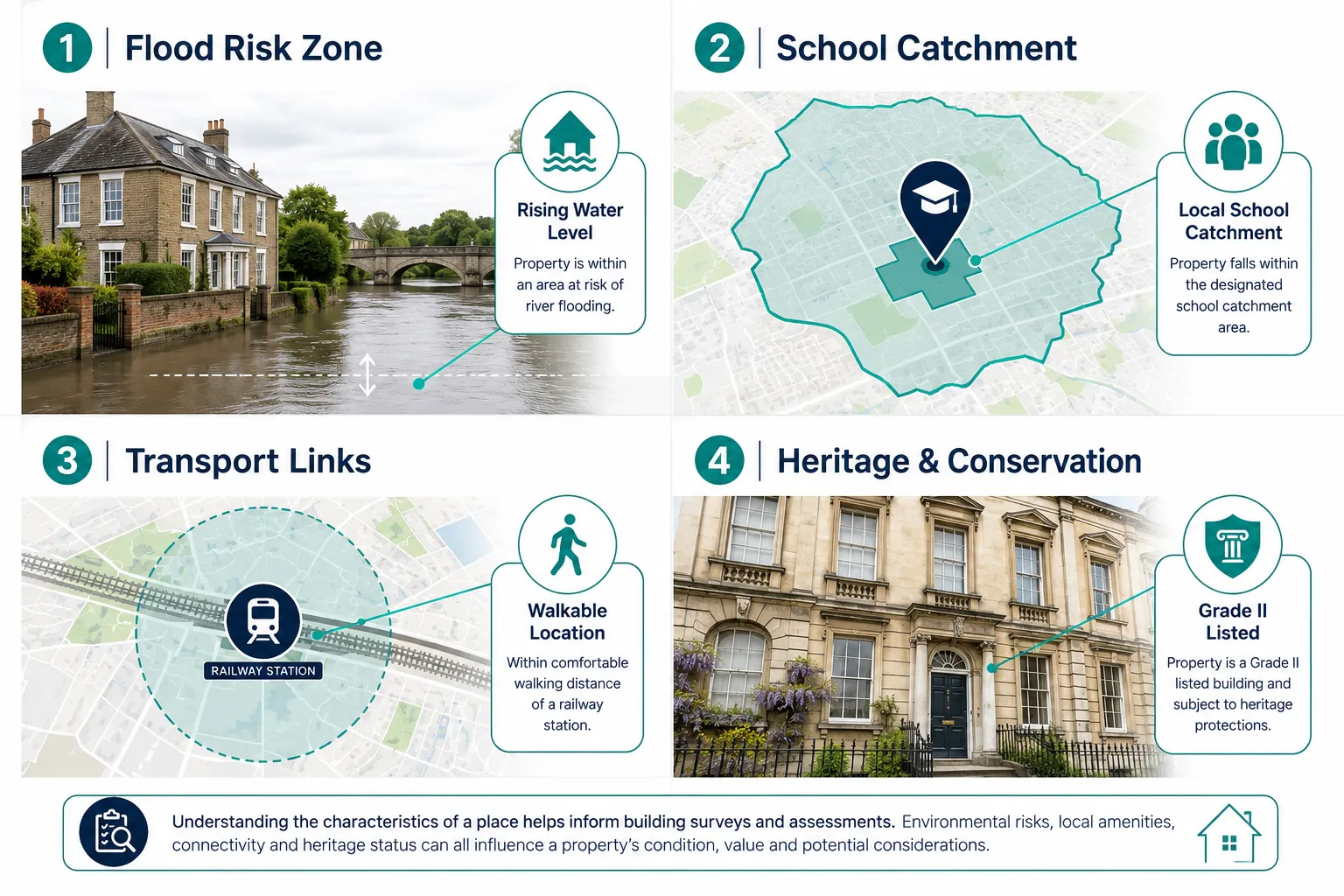
Physical and environmental characteristics include topography, soil type, proximity to watercourses, and exposure to natural hazards. A property sitting on shrinkable clay in a low-lying river valley carries a materially different risk profile from an identical house on well-drained chalk upland. Surveys for subsidence and damp surveys are often triggered precisely because place characteristics, soil movement, groundwater levels, prevailing weather exposure, create conditions that degrade building fabric over time.
Socioeconomic and amenity characteristics cover proximity to employment centres, quality of local schools, retail and leisure provision, crime rates, and deprivation indices. ONS research confirms that distance to London, access to jobs, and area deprivation are among the dominant drivers of house price variation across England and Wales, reinforcing a place-based view of risk that lenders and valuers must take seriously.
Planning and infrastructure characteristics include conservation area designations, listed building status, proximity to proposed development schemes, and transport investment pipelines. A confirmed HS2 station or a new tram line can shift local values significantly before a single rail is laid.
Governance and regulatory characteristics encompass flood risk zone classifications from the Environment Agency, radon risk mapping, noise exposure contours near airports, and air quality management areas. Each of these is a place-specific data layer that a competent surveyor must consult and report on.
How Place Matters in RICS Standards and the Red Book Framework
The RICS Red Book Global Standards, which govern valuation practice in the UK and internationally, make explicit that a valuer must consider the characteristics of the location as a core component of any valuation assignment [1]. The 2025 Valuation Report Framework reinforces this by requiring valuers to document their assessment of the locality, including factors that could affect marketability, saleability, and the sustainability of value over time [4].
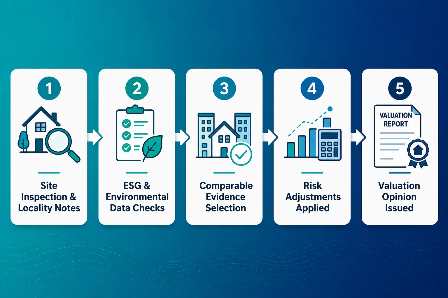
Critically, location characteristics are now formalised as environmental, social, and governance (ESG) data points within valuation methodology [3]. This means that a valuer cannot simply note “residential area” and move on. They are expected to consider flood risk classification, proximity to green infrastructure, walkability scores, and social infrastructure quality as quantifiable inputs that may require explicit adjustment to the comparable evidence selected [2].
The RICS placemaking guidance goes further, linking design quality, public realm, and connectivity directly to measurable price premiums [5]. Research cited in that guidance demonstrates that properties within well-designed, walkable neighbourhoods with accessible green space command consistent premiums over comparable stock in lower-quality environments. Strutt and Parker’s analysis of placemaking outcomes found that good place quality can add meaningful percentage uplifts to residential values, particularly where heritage character, tree canopy, and pedestrian connectivity combine [10].
For valuers and surveyors, this creates a professional obligation: place must be assessed systematically, not impressionistically. The Red Book valuation framework provides the structure within which those assessments are documented and justified.
Building Surveys and Place: Condition Meets Context
A building survey is primarily a condition assessment, it reports on the physical state of the structure, its elements, and its services. However, place characteristics shape both what a surveyor looks for and how they interpret what they find.
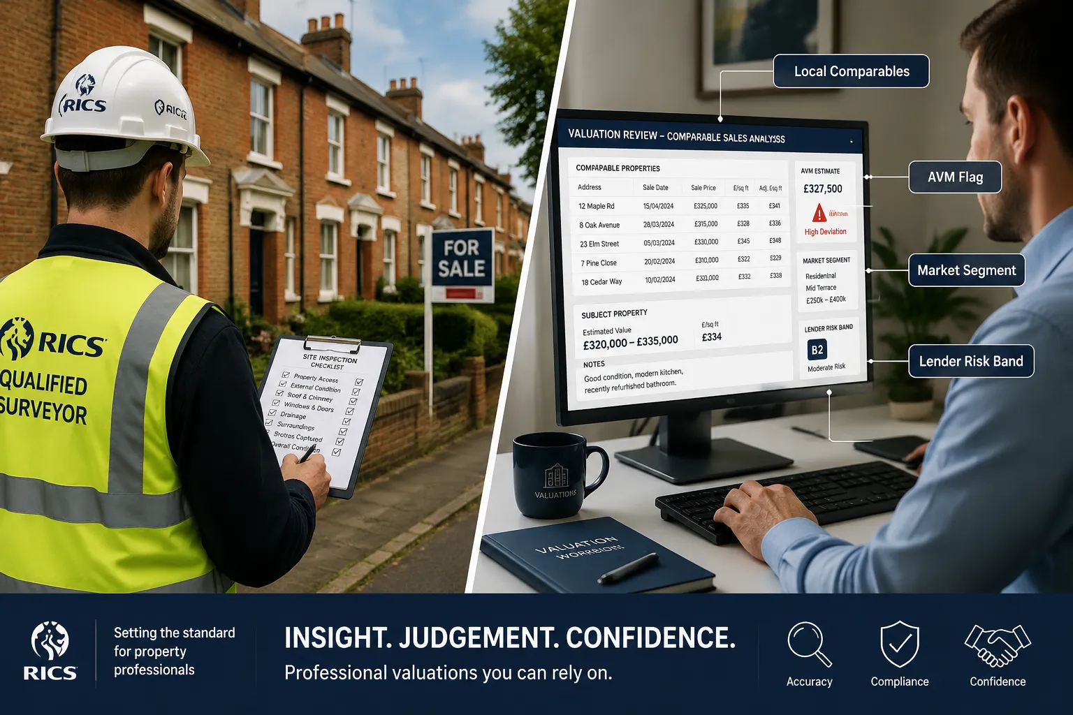
Consider flood risk. A property in Environment Agency Flood Zone 3 requires a surveyor to comment not only on whether the building has suffered flood damage but also on the implications for insurance, future mortgageability, and the adequacy of any flood resilience measures installed. A Level 3 building survey will typically include a more detailed commentary on environmental risks precisely because the depth of investigation matches the complexity of the place context.
Similarly, a property in a conservation area or with listed building status carries planning constraints that directly affect how defects can be remedied. A crumbling render on a listed Georgian terrace cannot simply be replaced with a modern silicone system, the surveyor’s condition report must flag not just the defect but the place-specific constraints on its repair, including the need for listed building consent and the use of lime-based materials.
Place characteristics that routinely influence building survey scope and commentary include:
- Flood risk zone and surface water drainage adequacy
- Radon gas potential (particularly in granite geology areas such as Cornwall, Devon, and parts of Scotland)
- Proximity to former industrial land or landfill (contamination risk)
- Conservation area or listed building designation (repair constraints)
- Subsidence-prone geology, including shrinkable clay and mining legacy areas
- Coastal exposure affecting weathering rates and material specification
- Proximity to large trees affecting foundations and drainage
For buyers considering properties in areas with specific geological or environmental risks, specialist surveys complement the standard building survey. Surveys for subsidence are a practical example of how place-specific risk translates into a targeted investigation protocol. Similarly, properties in high-risk subsidence zones warrant the detailed structural assessment that a Level 3 building survey for bungalows in high-risk subsidence zones provides, particularly given the thaw-freeze cycles affecting clay soils in 2026.
The choice of survey level should therefore reflect both the property’s construction type and its place context. A standard Victorian terrace in a low-risk inland location may be adequately served by a Level 2 RICS Home Survey, but the same property in a flood plain, a mining subsidence area, or a coastal erosion zone warrants the fuller investigation of a Level 3 survey. Guidance on when a homebuyer report is no longer sufficient is directly relevant here, as place risk is one of the clearest triggers for upgrading survey depth.
Mortgage Valuations and Place: How Lenders Segment Risk by Location
A mortgage valuation serves the lender, not the buyer. Its purpose is to confirm that the property provides adequate security for the loan, and place characteristics are central to that assessment. Lenders do not lend uniformly across all locations; they segment their risk appetite by geography, property type, and local market conditions.
Automated Valuation Models (AVMs) are now widely used by lenders for lower-risk, standard residential stock in well-transacted markets. AVMs rely on comparable sales data and location variables, precisely the kind of place-based evidence that makes them effective in stable, high-volume markets but unreliable in thin or unusual ones. Where place characteristics are complex, unusual, or rapidly changing, lenders require a physical inspection and a qualified valuer’s opinion rather than an algorithmic output.
The table below summarises how place characteristics influence lender valuation approach:
| Place Characteristic | Lender Response |
|---|---|
| Flood Zone 3 designation | Physical inspection required; reduced LTV or declined |
| Active mining subsidence area | Specialist report required; restricted lender panel |
| Conservation area / listed building | Physical inspection; repair cost implications noted |
| Declining local employment base | Reduced comparables confidence; value sustainability queried |
| Planned major infrastructure nearby | Positive or negative adjustment depending on type |
| High deprivation index | Reduced marketability weighting; some lenders withdraw |
| Strong school catchment premium | Supported by comparables; premium acknowledged |
The RICS Valuation Report Framework 2025 requires valuers to explicitly address factors affecting the sustainability of value, which in practice means commenting on whether place characteristics support or undermine the likelihood that the property will retain its value over the mortgage term [4]. This is particularly relevant for mortgage lender valuation audits, where professional negligence claims often arise from a failure to adequately weight place-based risk in the valuation opinion.
A valuation that ignores place is not a valuation, it is a measurement. The professional obligation is to interpret physical evidence in its full geographic and market context.
Regional patterns in the UK housing market reinforce the importance of place-based analysis. The 2026 UK Finance data highlights strong regional divergence in house price trajectories, with some northern and Welsh markets recovering faster than previously anticipated while certain coastal and rural markets face headwinds from demographic change and infrastructure underinvestment. Surveyors operating in these markets must calibrate their comparable evidence selection accordingly, ensuring that the sales data used to support a valuation opinion genuinely reflects current local conditions rather than national averages.
The Practical Interaction: When Place Affects Both Survey and Valuation Simultaneously
The most complex professional scenarios arise when place characteristics affect both the building survey condition commentary and the mortgage valuation opinion at the same time. This dual impact is most visible in the following situations.
Flood-affected properties present a clear example. A surveyor conducting a Level 3 survey on a riverside cottage must assess evidence of past flooding, the adequacy of flood resilience measures, and the condition of drainage infrastructure. Simultaneously, the valuer must consider whether the property’s flood risk designation reduces its pool of mortgage lenders, increases insurance costs to a level that affects affordability, and whether comparable sales evidence genuinely reflects an informed market or a thin one distorted by motivated sellers.
Properties in regeneration areas create a different dynamic. A structurally sound property in an area subject to major public investment, a new transport hub, a waterfront regeneration scheme, or a new school, may carry a current value that does not yet reflect the place improvement pipeline. A skilled valuer will note this in the report while being careful not to speculate beyond what the current market evidence supports [7].
Heritage and conservation contexts require surveyors to balance the value premium that listed status and conservation area designation can command against the repair cost premium and planning constraint burden they impose. A Georgian townhouse in a well-maintained conservation area may command a significant premium over an equivalent unlisted property, but only if the buyer and lender understand the ongoing maintenance obligations that place-based designation creates.
For buyers navigating these intersections, commissioning a RICS Home Survey from a local chartered surveyor with genuine knowledge of the specific place context is far more valuable than a generic national service. Local chartered surveyors bring accumulated knowledge of local geology, planning history, infrastructure pipelines, and market behaviour that cannot be replicated by a surveyor parachuted in from outside the area.
Actionable Guidance for Buyers, Sellers, and Lenders
Understanding how place characteristics interact with surveys and valuations leads to practical steps that all parties in a property transaction can take.
For buyers:
- Commission a survey level that reflects both the property’s construction complexity and its place risk profile, not just its age or price.
- Request that the surveyor explicitly addresses flood risk, ground conditions, and any planning constraints arising from the property’s location.
- Use the survey and valuation together: the survey tells you what the building is doing; the valuation tells you what the market thinks of the place.
- Where place risk is high, flood zone, subsidence area, contaminated land proximity, consider specialist investigations alongside the standard survey.
For sellers:
- Proactively gather evidence of place quality improvements: new transport links confirmed, school Ofsted ratings, regeneration investment announcements. These support the valuation case.
- Address any place-related defects that are within your control before marketing, flood resilience measures, drainage improvements, boundary tree management.
For lenders and their appointed valuers:
- Ensure that comparable evidence selection reflects genuine local market conditions, not national or regional averages that obscure place-specific dynamics.
- Apply ESG location data systematically as required by current RICS standards [2], [3], and document the basis for any adjustments made.
- Where place characteristics create valuation uncertainty, commission a physical inspection rather than relying on AVM outputs.
Conclusion
Place Matters: How ‘Place’ Characteristics Influence UK Building Surveys and Mortgage Valuations is not an abstract principle, it is a professionally mandated, evidence-based framework that shapes every competent survey and valuation in the UK market. From flood risk and soil type to school catchments, heritage designation, and infrastructure investment, the characteristics of a location are as material to a property’s condition assessment and market value as the state of its roof or the age of its boiler.
RICS standards now formalise this through the Red Book framework, the 2025 Valuation Report Framework, and ESG-linked location data requirements. Buyers who understand this framework are better positioned to commission the right level of survey, interpret the results in their full geographic context, and negotiate from a position of genuine knowledge. Lenders who apply it rigorously protect themselves from professional negligence exposure and ensure that their loan books reflect the real risk profile of the places they lend in.
Actionable next steps:
- Before commissioning a survey, research the place characteristics of the property, flood zone, soil type, conservation status, and local infrastructure plans.
- Choose a local chartered surveyor with demonstrable knowledge of the specific area, not just the property type.
- If place risk indicators are present, discuss upgrading to a Level 3 building survey and commissioning any specialist investigations recommended.
- Read the locality commentary in both the survey and the valuation report carefully, it is not boilerplate; it is the professional’s assessment of how place affects your investment.
References
[1] Red Book Global Standards Incorporating IVS – rics.org
[2] Valuation Standards – rics.org
[3] Quaderno 27 Valutazioni E ESG – assoimmobiliare.it
[4] Valuation Report Framework 2025 – rics.org
[5] Placemaking And Value 1st Edition – rics.org
[7] Methods And Models In Valuation – community.rics.org
[10] Good Placemaking Can Boost Home Values – struttandparker.com
Related services from Canterbury Surveyors
Get a fixed-fee quote or call 0204 579 8270.