
Canterbury & Kent
Ground Control Points and GPS in UK Boundary and Building Surveys: From Site Set-Out to Expert Witness Evidence
Boundary disputes now account for a significant share of neighbour litigation in England and Wales, with RICS data consistently showing a rise in contested boundary cases year on year [1]. Yet many property owners and solicitors still regard the surveyor’s GPS equipment as a black box, a device that produces coordinates without fully understanding how those coordinates are established, verified, and ultimately defended in court. This article demystifies that process. It explains how Ground Control Points and GPS in UK Boundary and Building Surveys: From Site Set-Out to Expert Witness Evidence form a connected chain of technical rigour, from the moment a surveyor drives the first ground marker into the soil to the moment a court-ready report lands on a judge’s desk.
Key Takeaways
- Ground control points (GCPs) are physical, precisely coordinated markers that anchor all GPS and total station measurements to the national coordinate system.
- GNSS practice in the UK converges on OS Net corrections, OSGB36 coordinates, and the OSGM15 geoid model for reliable, legally defensible results.
- HM Land Registry title plans show general boundaries only; a GPS-based measured survey is the only way to establish a precise legal boundary.
- The RICS 5th edition guidance on surveyors acting as expert witnesses directly governs how GPS and GCP evidence must be presented in dispute proceedings [4].
- Drone surveys now routinely require a minimum of five well-distributed GCPs to meet emerging 2026 best practice for boundary and building surveys [8].
What Are Ground Control Points and Why Do They Matter in UK Surveys
A ground control point is a physical marker, typically a survey nail, a concrete plug, or a precision-drilled bolt, whose position has been measured and recorded to a known accuracy within the national coordinate framework. Without GCPs, GPS measurements float in space. They may be internally consistent but they cannot be tied to the Ordnance Survey National Grid, verified independently, or reproduced by a different surveyor months or years later.
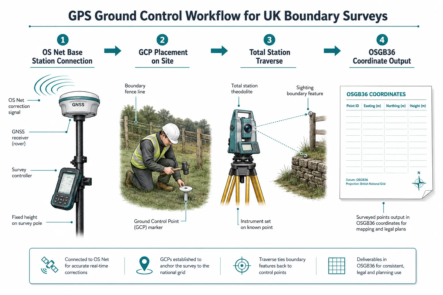
In UK practice, the coordinate framework is OSGB36, the horizontal datum maintained by Ordnance Survey. Heights are referenced to Ordnance Datum Newlyn via the OSGM15 geoid model. When a surveyor connects a GNSS receiver to OS Net, the national network of continuously operating reference stations, the resulting coordinates slot directly into this framework [5]. GCPs serve as the physical anchors that carry those coordinates from the instrument onto the ground, making measurements permanent, auditable, and legally defensible.
Why this matters for property owners and solicitors:
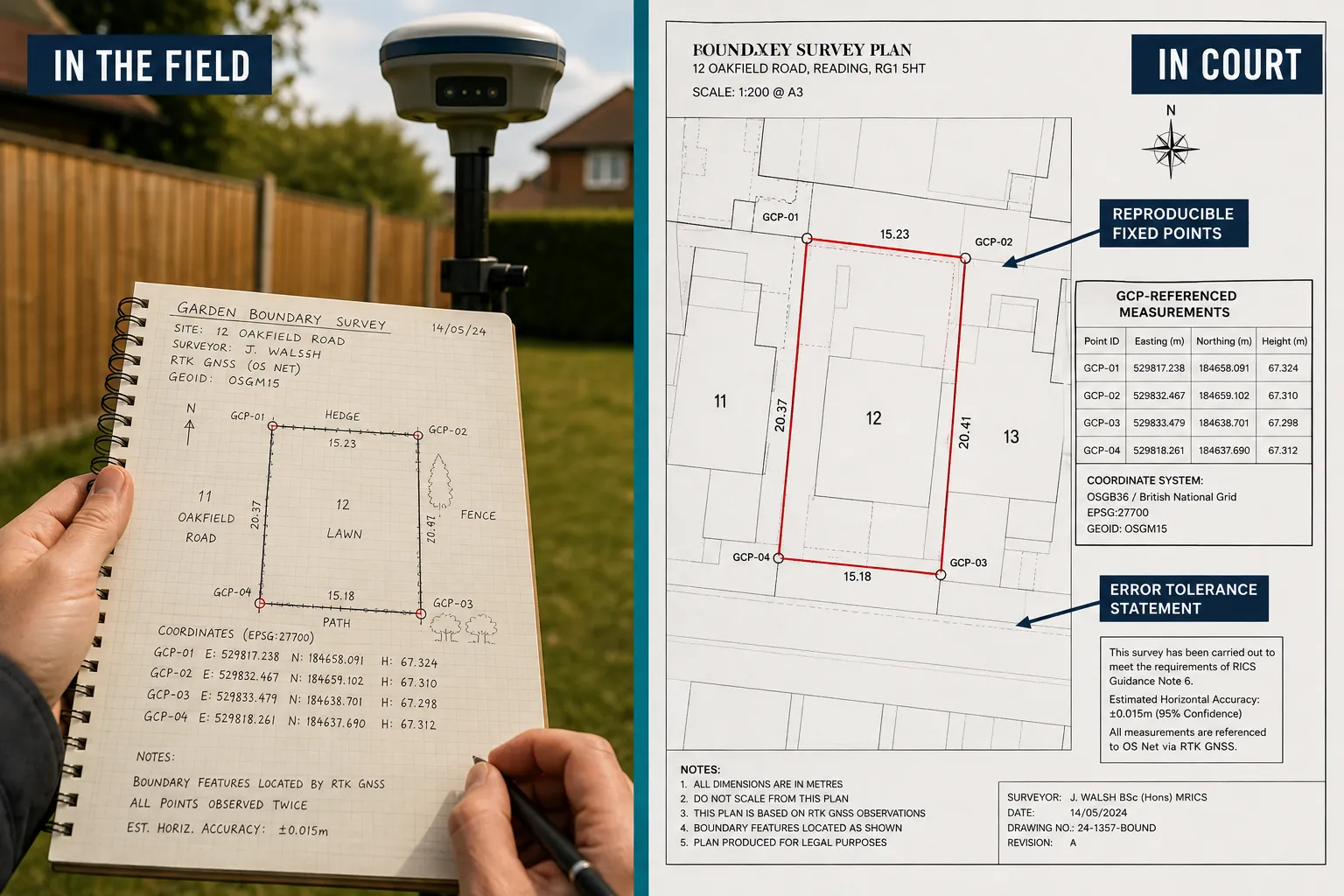
- A boundary measurement tied to GCPs can be re-run by any competent surveyor and should produce the same result within stated tolerances.
- A measurement without GCPs, or one tied only to temporary features such as fence posts, cannot be independently verified and will struggle under cross-examination.
- Courts and arbitrators increasingly expect surveyors to state their datum, their error budget, and their control network explicitly [4].
The Difference Between General and Legal Boundaries
HM Land Registry title plans are drawn from Ordnance Survey mapping at scales of 1:1250 or 1:2500. They show the general boundary of a registered title, not a precise legal line. The red edging on a title plan carries an uncertainty that can range from several centimetres to well over a metre at ground scale [3]. This is not a flaw in the system; it reflects the original purpose of the register, which is to record ownership, not to define millimetre-accurate lines.
When a dispute arises, or when a developer needs to set out a building precisely against a boundary, a GPS-based measured survey tied to GCPs is the only tool that can move from the general boundary to a measured, defensible position. RICS boundary guidance is explicit on this point, recommending that measured surveys by RICS-accredited surveyors form the evidential basis for any formal boundary dispute resolution process [1].
How GPS and Ground Control Points Work Together in UK Boundary and Building Surveys
Understanding the technical workflow helps property owners and solicitors assess the quality of survey evidence they receive. The process has four main stages.
Stage 1: Control network establishment
The surveyor selects a minimum of three GCPs around the site, though five or more are strongly recommended for larger areas or drone-based surveys [8] [9]. Each point is physically marked and observed using a GNSS receiver in static or rapid-static mode, connected to OS Net for real-time or post-processed corrections. The resulting coordinates are checked against at least one independent OS benchmark or passive control point to confirm no systematic error has entered the network.
Stage 2: Detail survey
A total station or GNSS rover is used to measure boundary features, fence lines, wall faces, hedge centres, gate posts, relative to the established GCPs. The total station is particularly valuable close to buildings and walls where satellite signals are obscured. The combination of GNSS for open areas and total station for confined spaces is standard UK practice [5].
Stage 3: Data processing and quality control
Raw observations are processed in survey software. Residuals, the small differences between measured and expected positions, are checked against project tolerances. For boundary surveys, a positional accuracy of 10-50 mm is typically achievable and should be stated explicitly in the survey report. For site set-out of building lines and floor levels, tolerances of 5-10 mm are common.
Stage 4: Reporting and archiving
The final deliverable includes a scaled plan, a coordinate schedule, a statement of datum and accuracy, and a description of the control network. These documents form the audit trail that allows the survey to be reproduced, challenged, or updated at any future date.
“The reproducibility of a GPS-based boundary survey is its single most important legal attribute. A result that cannot be independently verified is not evidence, it is opinion.”
Drone Surveys and the Expanding Role of GCPs
Unmanned aerial vehicle (UAV) surveys have become a practical tool for large boundary surveys, topographic mapping, and roof-level building surveys. However, a drone survey without adequate GCPs produces a photogrammetric model that may look impressive but carries positional errors of several decimetres or more.
Emerging 2026 best practice recommends a minimum of five well-distributed GCPs for any drone survey used in boundary or building evidence, with additional check points to validate the model independently [8] [9]. The GCPs must be pre-marked with targets visible in the imagery, observed by GNSS before the flight, and their coordinates included in the processing report. Without this, a drone survey cannot meet the evidential standards expected by RICS or the courts [8].
For professionals involved in expert witness inspections and evidence gathering for building and valuation disputes, understanding this distinction between a GCP-controlled and an uncontrolled drone survey is increasingly important when assessing the quality of opposing expert evidence.
Site Set-Out: Translating Coordinates into Physical Building Lines
Site set-out is the process of transferring design coordinates from a drawing or BIM model onto the ground so that construction follows the intended layout. It is one of the most direct applications of Ground Control Points and GPS in UK Boundary and Building Surveys: From Site Set-Out to Expert Witness Evidence, and errors at this stage can have significant legal and financial consequences.
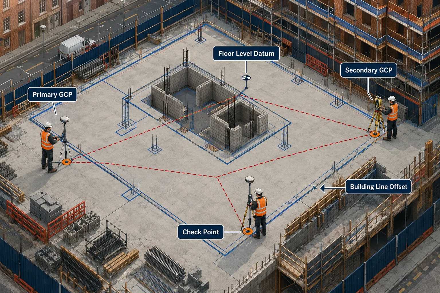
A typical set-out workflow begins with the design team issuing a coordinate schedule for building corners, column centres, and floor level datums. The surveyor establishes primary GCPs around the site perimeter, checks them against the project datum, and then uses a total station or GNSS rover to peg out the building lines. Secondary GCPs are placed within the building footprint as construction progresses, maintaining accuracy as floors rise and satellite visibility reduces.
Common set-out elements requiring GCP control:
| Element | Typical Tolerance | Instrument Used |
|---|---|---|
| Building line offset from boundary | +/- 10 mm | Total station |
| Column centre | +/- 5 mm | Total station |
| Floor level datum | +/- 3 mm | Digital level |
| Boundary peg position | +/- 20 mm | GNSS rover or total station |
| Drainage invert level | +/- 5 mm | Digital level |
When a building is constructed close to a boundary, the set-out record becomes a legal document. If a neighbour subsequently claims encroachment, the set-out survey tied to GCPs provides the primary evidence for or against that claim. This is why commercial building surveys and RICS Level 3 building surveys increasingly reference the original set-out data when assessing boundary proximity and potential encroachment.
Floor Levels, Drainage, and the Importance of a Consistent Datum
Floor levels matter in boundary and building disputes in ways that are not always obvious. A floor level that is 150 mm higher than the agreed datum can affect drainage gradients, flood risk assessments, and compliance with planning conditions. In party wall matters, the floor and foundation levels of adjoining structures are critical inputs to structural calculations.
All level data must be referenced to Ordnance Datum Newlyn via the OSGM15 geoid. A surveyor who references levels only to a temporary benchmark on site, without tying that benchmark to the national datum, produces data that cannot be compared to Environment Agency flood maps, highway drainage records, or the levels shown on planning drawings. For monitoring surveys tracking structural movement over time, a consistent national datum is not optional; it is the only basis on which change can be measured reliably.
From Survey Evidence to Expert Witness: Meeting RICS and Court Standards
The final and most demanding stage of Ground Control Points and GPS in UK Boundary and Building Surveys: From Site Set-Out to Expert Witness Evidence is the conversion of technical survey data into court-ready expert witness evidence. This is where technical rigour and professional conduct obligations converge.
The RICS 5th edition guidance on surveyors acting as expert witnesses, published in 2026, sets out clear requirements for how survey evidence must be presented [4]. The basis for conclusions document accompanying that guidance makes explicit that GPS-derived boundary data must include a statement of datum, a description of the control network, a quantified accuracy statement, and an explanation of any assumptions made in interpreting physical boundary features [7].
Key obligations under the 2026 RICS expert witness standard [4]:
- The surveyor must be able to explain the technical basis of their measurements in terms accessible to a non-technical judge or arbitrator.
- All GCP coordinates, instrument records, and processing reports must be retained and available for disclosure.
- Where two surveyors have reached different conclusions from GPS measurements, the difference must be explained with reference to datum, methodology, and tolerance, not dismissed as a matter of opinion.
- The duty to the court overrides any duty to the instructing party, including on technical matters such as the accuracy of GPS observations.
Professional conduct standards reinforce this position, making clear that a surveyor who overstates the precision of GPS measurements, or who fails to disclose the limitations of their control network, risks both disciplinary action and the exclusion of their evidence [6].
For solicitors handling boundary disputes, the practical implication is that a GPS survey report should always be scrutinised for its datum statement, its GCP description, and its accuracy quantification. A report that states only “GPS survey carried out” without these elements does not meet current RICS standards and may be vulnerable to challenge [1] [4].
Boundary Disputes: How GPS Evidence Is Used in Practice
In a typical boundary dispute, both parties may commission their own GPS surveys. The courts expect the surveyors to have attempted to agree a common datum and, where possible, to have carried out a joint inspection. RICS boundary guidance recommends this approach explicitly, noting that disputes often arise not from genuine disagreement about the physical evidence but from surveyors using different datums or different interpretations of the title plan [1] [5].
Where agreement cannot be reached, the expert witness report must set out:
- The physical features observed on site and their GPS coordinates.
- The title plan boundary and its relationship to those physical features.
- The historical evidence, conveyance descriptions, old photographs, witness statements, and how it aligns or conflicts with the measured survey.
- A clear statement of the surveyor’s opinion, supported by the GPS data, and an acknowledgement of any uncertainty.
For complex cases involving defect diagnosis in listed buildings or heritage constraints, the GPS evidence must also account for the fact that historic boundaries may have shifted over centuries of maintenance, encroachment, or informal agreement. The surveyor’s role is to measure what exists today and to explain, with reference to the documentary record, how that relates to the legal boundary as originally defined.
Solicitors and property owners seeking to understand expert witness roles in mortgage valuation and property disputes will find that the same standards of technical rigour applied to GPS boundary evidence are increasingly expected across all forms of surveying expert evidence in 2026.
Party Wall Matters and GPS Control
Party wall awards under the Party Wall etc. Act 1996 frequently require a schedule of condition to be prepared before notifiable works begin. Where those works are close to a boundary, or where the neighbouring structure is to be underpinned or built against, GPS-referenced levels and positions provide the baseline against which any future damage claims are assessed.
A schedule of condition report that includes GPS-referenced floor levels and wall positions is significantly more defensible than one that relies only on photographs and subjective descriptions. If a crack appears after construction, the GPS data allows the surveyor to determine whether any structural movement has occurred and to quantify it precisely.
For those navigating the intersection of party wall obligations and GPS survey evidence, the guidance on QS shortage impacts on building surveyor workloads and dilapidations highlights how increased workloads in 2026 make standardised, GCP-controlled survey protocols more important than ever for maintaining quality and defensibility.
Conclusion: Actionable Steps for Property Owners, Developers, and Solicitors
Ground Control Points and GPS in UK Boundary and Building Surveys: From Site Set-Out to Expert Witness Evidence represent a technical and legal standard that has matured significantly by 2026. The direction of travel is clear: more formalisation, stricter error reporting, and closer integration of GPS and GCP practice with RICS professional conduct and court evidence requirements.
Actionable next steps:
- For property owners in or approaching a boundary dispute: Commission a GPS-based measured survey from a RICS-accredited surveyor. Ask specifically for the datum statement, the GCP description, and the positional accuracy figure before accepting the report.
- For solicitors instructing expert witnesses: Check that any GPS survey report submitted as evidence meets the RICS 5th edition expert witness standard. A report without a stated datum and accuracy quantification is vulnerable to challenge.
- For developers and contractors: Ensure site set-out records are archived with their GCP coordinates and instrument logs. These documents may be needed years later if a boundary or encroachment dispute arises.
- For building surveyors: Where drone surveys are used for boundary or building evidence, apply the five-GCP minimum and include check-point residuals in the report. This is now expected practice, not optional enhancement [8] [9].
- For all parties: Engage a local chartered surveyor with demonstrable experience in GPS boundary work and expert witness reporting at the earliest stage of any dispute. Early, well-controlled survey evidence reduces costs and increases the likelihood of resolution without litigation.
The investment in proper GCP-controlled GPS survey work is modest compared to the cost of contested boundary litigation. More importantly, it produces evidence that is reproducible, transparent, and built to withstand scrutiny, which is exactly what courts, arbitrators, and RICS standards now demand.
References
[1] Boundaries Procedures For Boundary Identification Demarcation And Dispute Resolution Rics Guidance Note 4th Edition – rics.org
[2] Ded51040 4d69 4958 8811 Ab967cfed83b – contractsfinder.service.gov.uk
[3] Boundary Matters – isurv.com
[4] Surveyors Acting As Expert Witness 5th Edition Practice Guidance 30 November 2026 – isurv.com
[5] Boundaries Procedures For Boundary Identification Demarcation And Dispute Resolution October 2022 – rics.org
[6] Professional Conduct – isurv.com
[7] Basis For Conclusions Surveyors Acting As Expert Witnesses July 2026 – isurv.com
[8] Integrating Drone Surveys In Boundary Expert Witness Reports Rics Compliance For 2026 Land Registry Challenges – princesurveyors.co.uk
[9] Drone Survey Gcp Ground Control Uk 2026 – mmoww.net
[10] Boundary Dispute Resolutions 2026 Chartered Surveyor Strategies Beyond Party Wall Act Using Rics Mediation Protocols – princesurveyors.co.uk
Related services from Canterbury Surveyors
- Party wall surveyors in Canterbury & Kent
- Boundary surveys
- Building expert witness surveyors
- Dilapidations surveyors
Get a fixed-fee quote or call 0204 579 8270.