
Canterbury & Kent
Slope and Structural Risk: How a Simple ‘Slope’ Search Leads to Serious UK Building Survey Considerations
Nearly one in five properties in England and Wales sits on ground classified as having moderate to significant landslide susceptibility according to British Geological Survey data, yet the majority of buyers never ask about slope risk before exchanging contracts. The connection between Slope and Structural Risk: How a Simple ‘Slope’ Search Leads to Serious UK Building Survey Considerations is far more consequential than most homebuyers, landlords, and even some lenders appreciate. A quick online search for “slope” or “sloping garden” can open a chain of professional obligations, specialist assessments, and potential valuation adjustments that reshape the entire transaction.
Key Takeaways
- The BGS GeoSure Slope Instability dataset (version 8, updated August 2026) gives surveyors national coverage of landslide-susceptible zones, making desktop risk screening faster and more reliable than ever.
- Slope-related structural risk extends beyond visible gradients to include retaining walls, drainage paths, and foundation bearing conditions, all of which require systematic assessment in a Level 3 Building Survey.
- UK government planning guidance (updated July 2026) now explicitly requires slope-stability risk assessments at the earliest stage of any development on or near a slope.
- A standard Homebuyer Report (Level 2) is rarely sufficient for properties on or adjacent to slopes; a full Level 3 Building Survey is the appropriate professional response.
- Surveyors must consult national hazard datasets, not rely solely on visual inspection, when slope instability is a possibility.
Why Slope Risk Is More Than a Garden Feature
The word “slope” appears in thousands of UK property searches every month. Buyers type it when looking for hillside views, tiered gardens, or countryside settings. What they rarely anticipate is that the same topographic feature triggering aesthetic interest can also signal serious structural vulnerability.
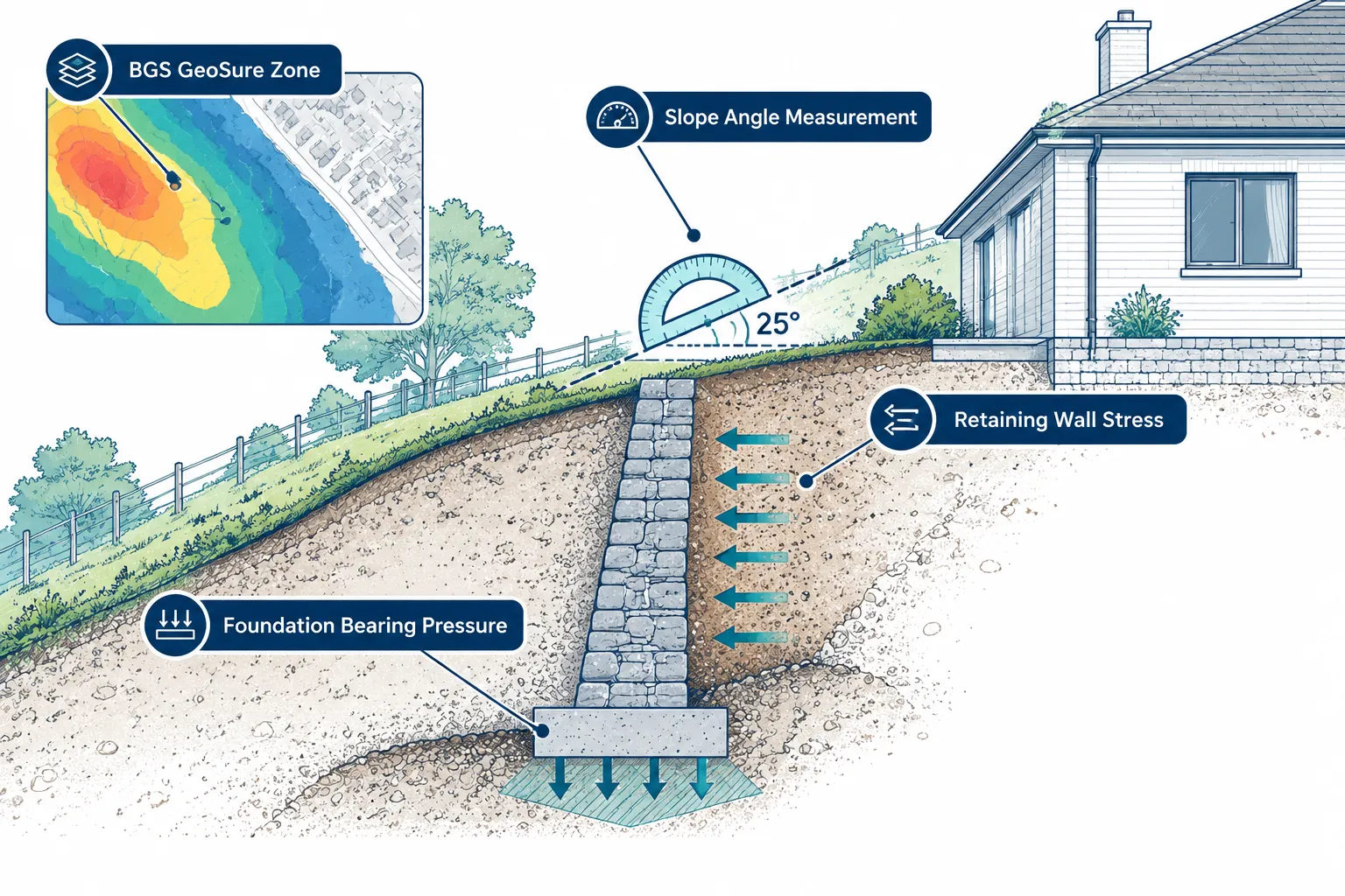
Slope instability, the tendency of ground materials to move downhill under gravity, water pressure, or loading, is one of the most under-reported hazards in residential property transactions. The British Geological Survey’s GeoSure dataset classifies susceptibility to slope failure across all of Great Britain, and its August 2026 version 8 update now provides building surveyors with the most comprehensive national coverage to date [2][4]. The dataset is explicitly designed to be “helpful and user-friendly” for professionals assessing ground movement risk to foundations and building fabric [2][4].
The complementary BGS Landslides Dataset (5 km Hex-Grid, version 8) takes this further by generalising susceptibility into hexagonal cells of approximately 64.95 km², rating each cell as Low (1), Moderate (2), or Significant (3) [3][5]. This means a surveyor, or indeed an insurer, can identify regional slope risk levels from a simple geographic query before any site visit takes place [3][5].
What does slope instability actually do to buildings?
The GeoSure Ground Stability Data Product (version 8, updated August 2026) makes the mechanism explicit: downslope movement of materials can damage foundations, rupture buried services, and cause direct structural impact to buildings [7]. These are not marginal risks. Foundation displacement caused by ground creep can manifest as diagonal cracking at window and door openings, sticking doors, and visible tilting of walls, defects that are expensive to remediate and difficult to insure once identified.
“Surveyors cannot rely on visual inspection alone when assessing properties near or on slopes.”, GeoSure Ground Stability Data Product guidance [7]
For properties in areas such as parts of South Wales, the Yorkshire Dales, the Pennines, and coastal cliff zones, slope risk is a primary structural concern rather than a secondary one. But slope instability is not confined to dramatic hillsides. Gentle, apparently stable gradients can conceal historic movement, particularly where made ground, fill material, or shrink-swell clays are present beneath the surface [7][13].
How Surveyors Assess Slope and Structural Risk in Practice
Understanding Slope and Structural Risk: How a Simple ‘Slope’ Search Leads to Serious UK Building Survey Considerations requires knowing exactly what a qualified building surveyor examines, and why a standard Homebuyer Report frequently falls short.
Desktop Research Before the Site Visit
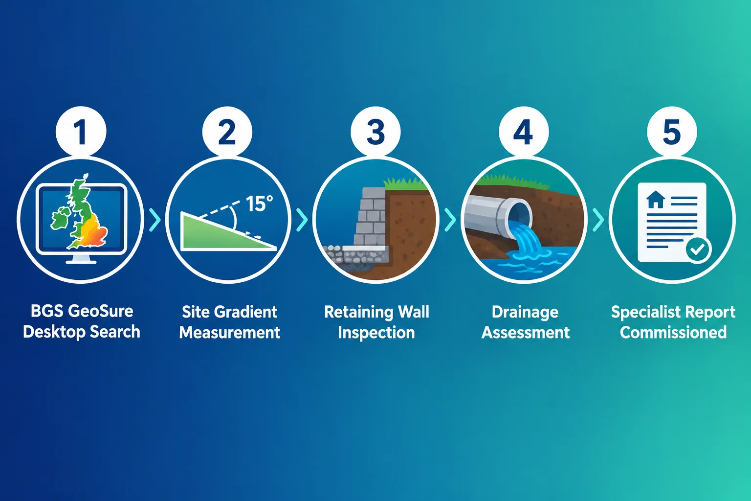
A rigorous slope-risk assessment begins at a desk, not on site. Before visiting a property, a competent surveyor will:
- Query the BGS GeoSure Slope Instability dataset to establish whether the postcode falls within a susceptible zone [2][4]
- Review the BGS Landslides Hex-Grid to understand regional susceptibility classification [3][5]
- Cross-reference the Property Subsidence Assessment (PSA) dataset for shrink-swell hazard at postcode and property level [13]
- Check the GeoSure Ground Stability Data Product for combined hazards including running sand, compressible ground, and dissolution features [7]
- Review historic Ordnance Survey mapping for evidence of former land uses, quarrying, or embankments
This desktop phase is not optional. The UK government’s Land Stability planning guidance (updated 15 July 2026) requires preliminary land-stability assessments at the earliest professional stage, and that principle extends to survey work as well as planning applications [14]. The guidance specifically requires consideration of whether slope instability originating outside a site’s boundaries could affect the property, a point that catches many surveyors and buyers off guard [14].
For guidance on what a full structural investigation involves and how it is priced, see this overview of structural survey pricing and what a structural survey costs.
On-Site Gradient and Retaining Wall Assessment
On site, the surveyor’s focus shifts to four interconnected elements:
1. Slope angle and orientation The angle of the ground relative to the building’s foundations determines the magnitude of lateral earth pressure. A slope of more than 1:10 (approximately 6 degrees) in proximity to foundations warrants specific commentary. Steeper gradients, particularly those exceeding 1:4, require specialist geotechnical input.
2. Retaining walls Retaining walls are among the most commonly defective elements on sloped residential sites. Common failure modes include:
| Defect Type | Visible Signs | Risk Level |
|---|---|---|
| Overturning | Wall leaning away from slope | High |
| Sliding | Horizontal displacement at base | High |
| Cracking | Vertical or diagonal cracks in masonry | Moderate-High |
| Drainage failure | Saturated ground behind wall, efflorescence | Moderate |
| Foundation erosion | Undermining at base of wall | High |
A retaining wall that is failing places lateral loading on adjacent structures and can trigger progressive slope movement. The surveyor must assess wall height, construction type, evidence of movement, and, critically, whether adequate drainage provision exists behind the wall.
3. Drainage assessment Water is the primary driver of slope instability. Poor drainage raises pore-water pressure within slope materials, reducing their shear strength and increasing the likelihood of movement. The surveyor should trace surface water paths, identify blocked or inadequate land drains, and note any evidence of ponding, erosion channels, or springs emerging at the slope face.
4. Foundation condition On sloped sites, foundations are frequently constructed at different depths across the building footprint, a condition known as “stepped foundations.” Where one part of a building sits on shallower or weaker bearing strata than another, differential settlement becomes a significant risk. Evidence of differential movement, asymmetric cracking patterns, sloping floors, or gaps between structural elements, must be recorded and investigated.
For properties where these indicators are present, the red flags that should trigger a full building survey are well-established in surveying practice.
When Specialist Input Is Required
Not every slope issue can be resolved within a standard Level 3 Building Survey. The following conditions typically require referral to a geotechnical engineer or structural engineer:
- Slopes exceeding 1:3 gradient adjacent to the building
- Evidence of historic or active landslide movement (hummocky ground, tension cracks, displaced trees)
- Retaining walls over 1.2 metres in height showing signs of movement
- Properties within BGS GeoSure Significant (3) susceptibility zones
- Any proposed extension, basement, or excavation on a sloped site
The RICS Home Survey Standard (updated June 2026) now includes explicit frameworks for “additional risk” dwellings, positioning ground and structural risk, including slope instability, as a mainstream reporting requirement rather than an optional commentary item [10]. This reflects a broader professionalisation drive within the sector, with RICS standards emphasising that appropriately qualified professionals and measured surveys are required wherever land-stability concerns are present [8].
Survey Level Choices and the Slope Risk Decision
Slope and Structural Risk: How a Simple ‘Slope’ Search Leads to Serious UK Building Survey Considerations is ultimately a question of survey scope, and choosing the wrong level of survey on a sloped property is one of the most costly mistakes a buyer can make.
Level 2 vs Level 3: Why Slope Changes the Calculation
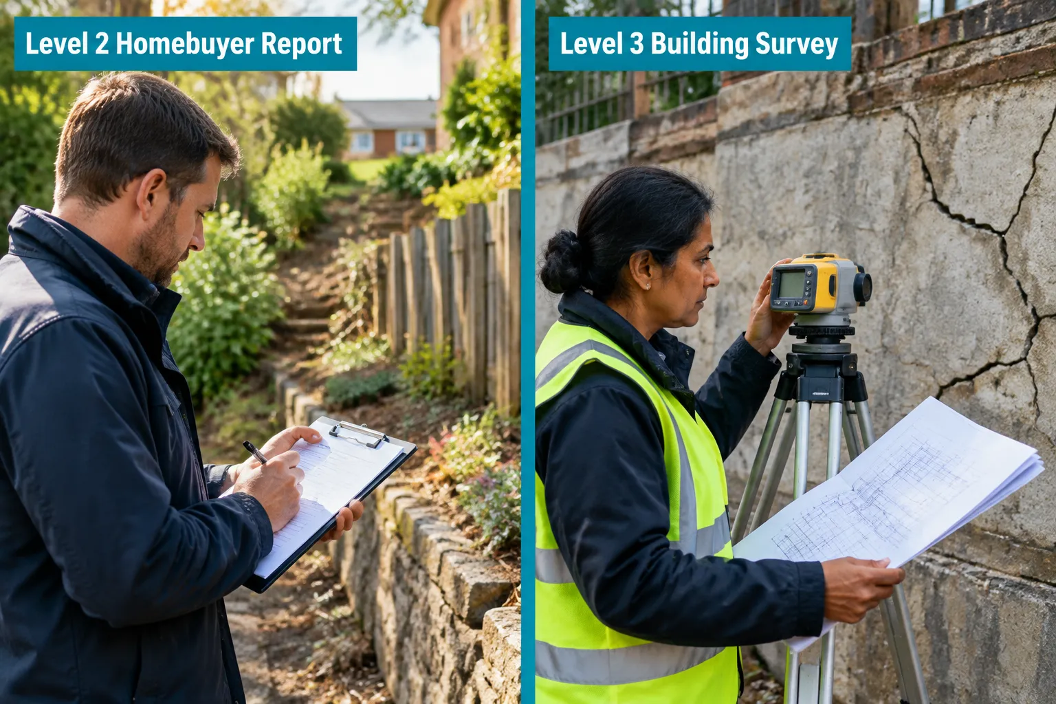
A Level 2 Homebuyer Report is appropriate for conventional properties in reasonable condition. It is a visual inspection that does not include opening up of construction or specialist investigations. On a sloped site, this limitation is significant. The surveyor conducting a Level 2 report cannot probe behind retaining walls, assess drainage infrastructure, or commission geotechnical testing. The result is a report that may note “sloping ground to the rear” without quantifying the structural implications.
A Level 3 Building Survey, the most comprehensive residential survey available, provides the depth of investigation that sloped sites demand. It includes:
- Detailed assessment of all accessible structural elements
- Commentary on ground conditions and their likely effect on the building
- Specific recommendations for specialist investigations where warranted
- Advice on maintenance, remediation, and risk management
For a detailed comparison of these two approaches, the difference between Level 2 and Level 3 surveys is worth reviewing before commissioning any survey on a property with gradient features.
Industry analysis from June 2026 on proposed second-edition changes to the RICS Home Survey Standard notes a move toward more descriptive survey terminology, “Basic, Intermediate, Advanced”, alongside more operationally specific service checks [10]. This evolution will make slope-related structural risk commentary more explicit and standardised in survey outputs, benefiting both buyers and lenders.
Historic Subsidence and Previous Structural Movement
Sloped sites frequently have histories of ground movement that predate the current owners’ tenure. A property that has experienced previous slope-related subsidence may have been underpinned, have crack repairs concealed beneath fresh decoration, or have retaining walls rebuilt without adequate drainage. These interventions are not always disclosed in seller questionnaires.
Surveyors investigating properties with any history of structural movement, whether slope-related or otherwise, should approach the assessment with heightened scrutiny. The investigation and disclosure obligations for homes with historic subsidence or previous structural movement are a critical reference point for this work.
For properties where subsidence is a specific concern alongside slope risk, a dedicated subsidence survey may be required in addition to the standard building survey.
Soil and Water Contamination on Sloped Sites
Sloped sites present an additional risk that is less commonly discussed: contamination migration. Where a property sits downslope of former industrial land, filled ground, or agricultural land treated with chemicals, contaminants can migrate through the soil profile and groundwater toward the lower site. This is particularly relevant for properties in valleys or at the base of escarpments.
The assessment of soil and water contamination is a specialist discipline that intersects directly with slope-risk assessment in these scenarios.
Party Wall Considerations on Sloped Terrain
Sloped sites complicate party wall matters significantly. Where a property owner wishes to excavate, build a retaining wall, or carry out foundation work near a shared boundary on a slope, the Party Wall etc. Act 1996 obligations are triggered. The surveyor must consider not only the immediate structural impact but also the potential for slope movement to affect the adjoining owner’s land, particularly where the neighbouring property sits upslope or downslope of the proposed works.
Practical Steps for Buyers, Owners, and Surveyors in 2026
The integration of national hazard datasets into routine survey practice is accelerating. The BGS GeoSure suite, now at version 8 across multiple datasets [2][4][7], gives surveyors no excuse for overlooking slope risk at the desktop research stage. The UK government’s updated Land Stability guidance [14] and the evolving RICS Home Survey Standard [10] together create a clear professional expectation: slope risk must be systematically identified, assessed, and reported.
For buyers:
- Always commission a Level 3 Building Survey for properties on or adjacent to slopes, regardless of the property’s apparent age or condition.
- Ask the surveyor explicitly whether they have consulted BGS GeoSure data and what susceptibility classification applies to the site.
- Budget for specialist geotechnical investigation if the survey recommends it, this typically costs between £500 and £2,500 depending on scope.
For existing owners:
- Monitor retaining walls annually for signs of movement, drainage failure, or cracking.
- Ensure land drains and soakaways are cleared regularly, particularly before winter.
- Consult a structural engineer before any excavation, extension, or significant landscaping on a sloped site.
For surveyors:
- Integrate BGS GeoSure Slope Instability [2][4] and the Landslides Hex-Grid [3][5] into every pre-survey desktop review for properties in topographically varied areas.
- Apply the RICS Home Survey Standard’s “additional risk” frameworks [10] and RICS building surveying risk management standards [6][8] when slope instability is identified.
- Document the basis for any recommendation for specialist investigation clearly, referencing the specific dataset findings and on-site observations that triggered the recommendation.
For surveyors working within the context of the latest professional standards, the RICS 2026 building survey quality standards and consumer transparency initiative provides essential guidance on meeting evolving client and regulatory expectations.
Conclusion
Slope and Structural Risk: How a Simple ‘Slope’ Search Leads to Serious UK Building Survey Considerations is not an abstract concern for edge-case properties. It is a live, data-supported professional obligation that applies to a substantial proportion of the UK housing stock. The August 2026 updates to the BGS GeoSure datasets [2][4][7], the refreshed UK government Land Stability guidance [14], and the evolving RICS Home Survey Standard [10] together create an environment in which slope risk must be treated with the same rigour as damp, subsidence, or structural movement.
Actionable next steps:
- Before purchasing any property with visible gradient features, commission a Level 3 Building Survey from a RICS-regulated firm with demonstrable experience in ground-risk assessment.
- Ask your surveyor to confirm that BGS GeoSure data has been consulted and that the site’s susceptibility classification has been recorded in the report.
- If the survey identifies retaining wall defects, drainage failures, or evidence of ground movement, obtain a specialist geotechnical report before proceeding with the purchase.
- For development or extension projects on sloped sites, engage a structural or geotechnical engineer at the earliest planning stage, as UK government guidance now explicitly requires [14].
- Revisit slope-risk assessments after significant rainfall events or periods of prolonged drought, both of which can alter ground conditions materially.
The relationship between topography and structural integrity is well-understood by experienced surveyors, but it remains poorly communicated to the buyers and owners who bear the financial consequences. Closing that gap is precisely what a thorough, data-informed building survey is designed to do.
References
[1] Building Surveying December 2025 – rics.org
[2] Geosure Slope Instability2 – data.gov.uk
[3] Landslides Dataset 5km Hex Grid Version 7 – data.gov.uk
[4] Geosure Landslides Slope Instability Version 8 – data.gov.uk
[5] Landslides Dataset 5km Hex Grid Version 8 – data.gov.uk
[6] Profession Standards – rics.org
[7] Geosure Ground Stability Data Product Version 8 – data.gov.uk
[8] Building Surveying Standards – rics.org
[9] Design And Specification – rics.org
[10] Home Survey Standards – rics.org
Related services from Canterbury Surveyors
- Party wall surveyors in Canterbury & Kent
- Boundary surveys
- RICS property valuations
- RICS Homebuyer Surveys (Level 2)
Get a fixed-fee quote or call 0204 579 8270.