
Canterbury & Kent
GNSS and GPS Enhancements: Achieving Centimeter-Level Accuracy in Real-Time Property Measurements
“
A boundary line error of just 30 centimeters once triggered a legal dispute that cost two neighbouring homeowners over £40,000 in combined legal and surveying fees. That figure illustrates exactly why GNSS and GPS Enhancements: Achieving Centimeter-Level Accuracy in Real-Time Property Measurements has become one of the most consequential technological shifts in modern land surveying. What was once achievable only with expensive, slow, post-processed data is now available in real time, on-site, with sub-centimetre precision, transforming how surveyors, engineers, and property professionals work across the UK and beyond.
Key Takeaways
- Modern GNSS technology combines signals from multiple satellite constellations to deliver real-time positioning accuracy of 1-2 centimetres.
- Real-Time Kinematic (RTK) and Precise Point Positioning (PPP) are the two primary correction techniques driving centimetre-level accuracy in property surveys.
- Centimetre-accurate GNSS data is now central to resolving boundary disputes, producing cadastral maps, and supporting large-scale land registration.
- Multi-constellation receivers, improved signal processing, and national correction networks have dramatically reduced cost and setup time for high-precision surveys.
- Chartered surveyors who integrate advanced GNSS tools can deliver faster, more defensible results for clients involved in property transactions, disputes, and development projects.
How Modern GNSS Technology Works
From Single-Constellation GPS to Multi-Constellation GNSS
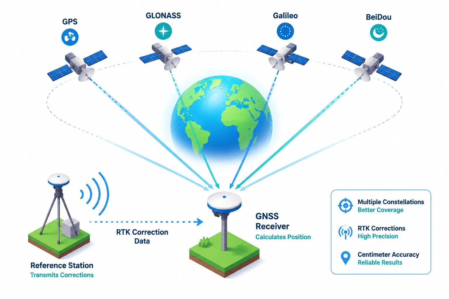
The term “GPS” is often used as a catch-all, but it refers specifically to the United States’ Global Positioning System, one of several Global Navigation Satellite Systems now operational. In 2026, surveyors routinely draw on four major constellations simultaneously:
| Constellation | Operator | Satellites (approx.) |
|---|---|---|
| GPS | United States | 31 |
| GLONASS | Russia | 24 |
| Galileo | European Union | 28 |
| BeiDou | China | 45+ |
Using signals from all four constellations rather than GPS alone delivers two critical advantages: more satellites in view at any moment and geometric diversity in signal angles. Both factors directly reduce positioning error.
A standard single-constellation GPS receiver achieves horizontal accuracy of roughly 3-5 metres under open-sky conditions. A modern multi-constellation GNSS receiver, applying correction techniques described below, routinely achieves 1-2 centimetres in real time.
The Physics of Positioning Error
GNSS receivers calculate position by measuring the travel time of radio signals from satellites. Even tiny errors in this measurement compound quickly. The main sources of error include:
- Ionospheric delay, the electrically charged upper atmosphere slows signals unpredictably.
- Tropospheric delay, water vapour in the lower atmosphere causes additional signal bending.
- Multipath interference, signals reflecting off buildings or terrain arrive at the receiver along multiple paths, corrupting the measurement.
- Satellite clock and orbit errors, tiny inaccuracies in the satellite’s own clock and predicted orbit position.
Correction technologies attack each of these error sources systematically, which is why they are the foundation of centimetre-level GNSS performance.
Real-Time Kinematic (RTK) Correction
Real-Time Kinematic (RTK) is the correction method most widely used in professional property surveying today. It works by pairing a mobile “rover” receiver on-site with a fixed “base station” receiver at a known, precisely surveyed location nearby.
The base station continuously measures the errors in its own GNSS signals, errors that are nearly identical at the rover because both receivers are close together (typically within 10-30 km). Those error corrections are transmitted to the rover in real time, usually via radio or mobile internet, and applied instantly to the rover’s position calculation.
The result: the rover achieves horizontal accuracy of 8-15 mm and vertical accuracy of 15-20 mm in real time, without any post-processing delay.
Network RTK extends this concept by replacing a single base station with a network of continuously operating reference stations (CORS). In the UK, Ordnance Survey operates the OS Net network of over 110 reference stations. A rover connected to OS Net receives corrections computed from the nearest cluster of stations, delivering RTK-quality accuracy across the entire country without the surveyor needing to set up their own base station.
Precise Point Positioning (PPP)
Precise Point Positioning (PPP) takes a different approach. Instead of relying on a nearby base station, PPP uses highly accurate satellite clock and orbit corrections broadcast from global monitoring networks. The rover applies these corrections independently, without needing a local reference.
PPP historically required 20-30 minutes of “convergence time” before reaching centimetre accuracy. Newer PPP-RTK hybrid systems, now commercially available in 2026, combine PPP’s global reach with RTK’s fast convergence, achieving centimetre accuracy in under two minutes in many conditions. This is particularly valuable for surveys in remote areas where no CORS network exists.
Practical Applications in Property Surveying and Boundary Disputes
Why Centimetre Accuracy Changes Everything for Property Professionals
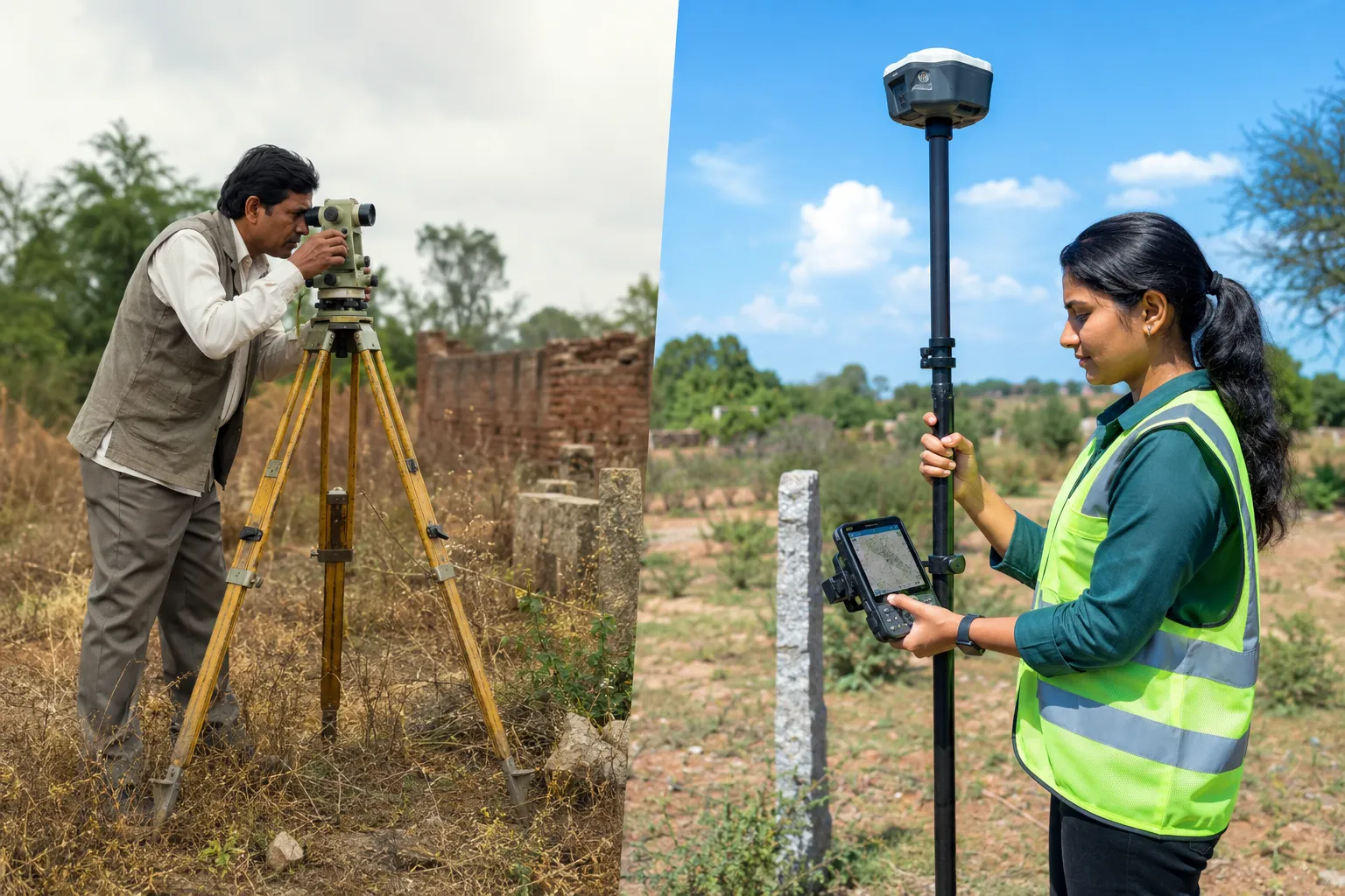
The leap from metre-level to centimetre-level accuracy is not merely a technical improvement, it changes what is legally and professionally defensible. For boundary surveys, the difference between a position measured to ±50 cm and one measured to ±1 cm can determine whether a fence, wall, or extension encroaches on a neighbouring property.
“A boundary error that falls within the tolerance of older survey methods can still represent a real physical encroachment of hundreds of square metres on a large plot, and thousands of pounds in property value.”
Chartered surveyors handling boundary disputes increasingly rely on RTK GNSS data to produce coordinates that can be independently verified, compared against historical deeds, and presented as evidence in legal proceedings. The precision also integrates directly with the Land Registry’s digital mapping systems, making registration of new or corrected boundaries faster and more accurate.
For anyone involved in a boundary dispute, understanding the three-metre rule and related boundary regulations is essential context, and precise GNSS measurements are increasingly the evidence base on which such rules are applied.
Large-Scale Cadastral Mapping
Cadastral mapping, the official recording of property ownership boundaries, depends on consistent, reproducible coordinate data. National mapping agencies and local authorities across the UK are progressively migrating their cadastral databases to GNSS-derived coordinates tied to the national coordinate reference frame (ETRS89/OSGB36).
GNSS and GPS Enhancements: Achieving Centimeter-Level Accuracy in Real-Time Property Measurements plays a central role in this migration. Key applications include:
- Re-surveying legacy boundaries originally measured with chain surveys or early optical instruments, where accumulated errors can reach several metres.
- Mapping new developments with coordinates that integrate seamlessly into national databases.
- Monitoring subsidence and land movement by re-occupying GNSS control points over time to detect millimetre-scale shifts, directly relevant to structural surveys and residential structural engineering assessments.
Integration with Drone and LiDAR Surveys
Modern GNSS is rarely used in isolation. In 2026, high-precision GNSS is the positioning backbone for:
- UAV (drone) photogrammetry, RTK-enabled drones capture aerial imagery with each photo tagged with centimetre-accurate coordinates, producing orthorectified maps and 3D models without the need for large numbers of ground control points.
- Mobile LiDAR scanning, vehicles or backpack-mounted LiDAR systems use GNSS/IMU (Inertial Measurement Unit) integration to geo-reference millions of point cloud measurements per second.
- BIM (Building Information Modelling), survey-grade GNSS coordinates anchor BIM models to real-world positions, ensuring that digital twins of buildings and infrastructure reflect actual ground conditions.
These integrations are particularly relevant for commercial building surveys and large-scale development projects where multiple disciplines need to share a common spatial reference.
Limitations and Practical Considerations
Even the most advanced GNSS systems face real-world constraints that surveyors must manage:
- Urban canyons, tall buildings block and reflect satellite signals, degrading RTK accuracy significantly. In dense urban environments, surveyors often supplement GNSS with total stations or terrestrial laser scanning.
- Tree canopy, dense vegetation attenuates signals. Surveyors working in woodland settings may need to use multiple occupation periods or traverse methods to achieve the required accuracy.
- GNSS outages, solar weather events can disrupt ionospheric conditions and degrade accuracy temporarily.
- Coordinate system transformations, converting between global GNSS coordinates (WGS84) and national grid systems (British National Grid) introduces small transformation errors that must be managed carefully in legal boundary work.
Understanding these limitations is as important as understanding the technology’s capabilities. A surveyor who presents RTK data without acknowledging the conditions under which it was collected risks producing a report that is challenged in court.

GNSS Enhancements Driving the Next Generation of Accuracy
Multi-Band Receivers and Signal Diversity
Early GPS receivers tracked only the L1 signal (1575.42 MHz). Modern GNSS receivers track multiple frequency bands simultaneously, L1, L2, and L5 for GPS; equivalent bands for Galileo, GLONASS, and BeiDou. Multi-frequency tracking provides two major benefits:
- Ionospheric error elimination, by comparing signal travel times at two different frequencies, the receiver can calculate and remove the ionospheric delay almost entirely.
- Faster ambiguity resolution, the mathematical process of determining the exact number of signal wavelengths between satellite and receiver (the “integer ambiguity”) converges far more quickly with multiple frequencies, reducing the time to achieve centimetre accuracy from minutes to seconds.
The cost of multi-frequency, multi-constellation receivers has dropped dramatically. In 2026, survey-grade RTK systems are available from multiple manufacturers at price points that make them accessible to small surveying practices, not just large infrastructure firms.
Augmentation Systems: SBAS and PPP Services
Satellite-Based Augmentation Systems (SBAS) broadcast correction signals from geostationary satellites. In Europe, the EGNOS system (European Geostationary Navigation Overlay Service) provides sub-metre accuracy for aviation and is increasingly used in precision agriculture and surveying as a backup or supplementary correction source.
Commercial PPP correction services, including Trimble’s RTX, Hexagon’s TerraStar, and Swift Navigation’s Skylark, now deliver global centimetre-level corrections via internet or satellite L-band broadcast. These services are particularly valuable for offshore surveys, remote infrastructure projects, and any application where establishing a local base station is impractical.
Machine Learning and Signal Processing Advances
Signal processing algorithms have advanced significantly alongside hardware improvements. Machine learning models trained on large datasets of GNSS observations can now:
- Predict and compensate for multipath interference patterns in known environments (such as urban canyons with fixed building geometry).
- Improve ambiguity resolution success rates in challenging sky-view conditions.
- Detect and exclude faulty satellite signals (a process called “integrity monitoring”) more reliably than traditional statistical methods.
These software advances mean that the accuracy improvements from GNSS and GPS Enhancements: Achieving Centimeter-Level Accuracy in Real-Time Property Measurements are not solely dependent on buying new hardware, firmware and software updates can meaningfully improve the performance of existing receivers.
The Role of Ordnance Survey and National Infrastructure
In the UK, OS Net remains the cornerstone of high-precision GNSS for property professionals. The network’s 110+ continuously operating reference stations are monitored 24/7, and corrections are available via the OS Net API to any licensed user with a compatible receiver and mobile data connection.
OS Net corrections are used in conjunction with the National Geoid Model (OSGM15), a detailed model of the Earth’s gravity field that allows GNSS ellipsoidal heights to be converted to the Ordnance Datum Newlyn (ODN) heights used on Ordnance Survey maps. This conversion is critical for drainage, flood risk, and construction surveys where accurate vertical data is as important as horizontal position.
Surveyors conducting schedule of condition reports or dilapidation surveys increasingly reference GNSS-derived coordinates to establish unambiguous spatial context for documented defects and measurements, a practice that strengthens the evidential value of reports in dispute resolution.
What This Means for Property Valuation and Development
Precise spatial data does not only serve surveyors in the field. It flows directly into the data foundations that support property valuation methods and development appraisals. Accurate plot areas, verified boundary positions, and reliable topographic data all reduce the risk premium that valuers and developers must factor into assessments of sites with uncertain physical characteristics.
As GNSS accuracy improves and costs fall, the expectation that property professionals will use centimetre-grade data, rather than relying on scaled measurements from existing maps, is becoming a professional standard rather than a premium service.
Conclusion
The convergence of multi-constellation receivers, network RTK corrections, multi-frequency signal processing, and machine learning has made centimetre-level real-time positioning a practical reality for everyday property surveying. GNSS and GPS Enhancements: Achieving Centimeter-Level Accuracy in Real-Time Property Measurements is no longer a niche capability reserved for large infrastructure projects, it is an accessible, affordable, and increasingly expected standard for boundary surveys, cadastral mapping, structural monitoring, and development appraisals across the UK.
Actionable next steps for property professionals:
- Audit your current survey equipment. If your GNSS receivers are single-frequency or single-constellation, upgrading to a dual-frequency multi-constellation system will deliver immediate accuracy improvements.
- Connect to OS Net. Ensure your practice has a current OS Net licence and that field teams are trained to use network RTK corrections rather than relying on standalone positioning.
- Document your methodology. For any survey that may be used in legal proceedings, particularly boundary disputes, record the equipment used, the correction source, the number of satellites tracked, and the PDOP (Position Dilution of Precision) values at the time of measurement.
- Integrate GNSS data with your reporting workflows. Coordinate data should flow directly into CAD, GIS, and BIM platforms to eliminate transcription errors and provide clients with spatially referenced deliverables.
- Consult a chartered surveyor. For boundary disputes, development appraisals, or any situation where spatial accuracy has legal or financial consequences, engage a qualified professional who can both collect and interpret high-precision GNSS data correctly.
The technology has arrived. The question now is whether the professionals using it are equipped to extract its full value, and to explain that value clearly to the clients who depend on it.
Related services from Canterbury Surveyors
Get a fixed-fee quote or call 0204 579 8270.